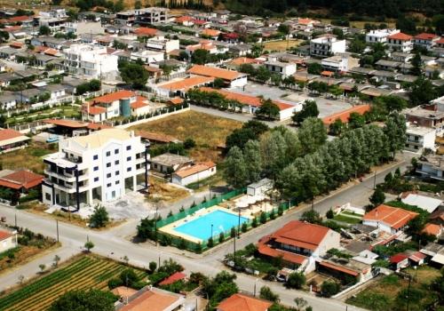
Megalopolis city
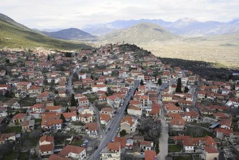
At 18 km from our villa, after 30 minutes of distance by your means of transport, you can find the capital of the municipality belonging to the village of Ano Karyes, located in our villa, Megalopolis. In Megalopolis you will find an organized market for your shopping, for your banking transactions, for your medical or pharmaceutical needs. You can also take your walk in the city, drink your coffee and visit its ancient theater.

Megalopolis and Antiquities
Megalopoli, one of the most important cities of the prefecture, has its own contribution to the history of the region. It was built in 370 BC. by order of Thebes Epaminondas. Pausanias in “Arcadia” says that the theater was the largest in Greece.
It was in the antiquity a cultural and spiritual center that helped to cultivate the Arcadians spiritually. Even today, the splendor of the majestic ancient era keeps alive. The continuation of the theater was the stadium for athletic competitions. It is estimated that 18 and 20 thousand people could sit there. Excavations of the British Institute brought to light the sun, the orchestras, the presidencies, the lower stone stables of the theater, the lifts of the lanes and the foundations of “Thersilio”, which was adjacent to the theater.
The “Thersilio” was the parliamentary chamber of the Arcadians, the famous House of Myrion, in which representatives of all Arcadian cities took part. His name was taken by Thersilos, from Orchomenos, and symbolizes the idea of the unity and democratic rule of the peoples. The existence of this building proves the profoundly democratic nature of the Arcadians, their free thinking, elements that have significantly influenced the entire later civilization of the region, but also the culture of the whole of Greece.

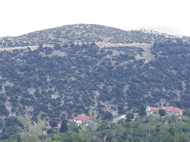
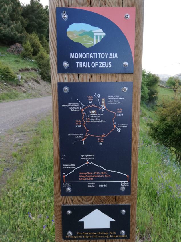
Near the village there is a very strong and impressive location called “Kelia”, where there is a fortified cave with mounds in the middle of huge vertical rocks, which was the base of kleftourias before 1821, there were those who were persecuted by the Turks, people of Karyes and the people of other near villages. In the area of Ano Karyes there are several peaks of Lykaio Mount, some of which are historical “Diaforti” (Zeus bears), “Ai-Lias”, “Tabouri”, “Tzorokos”, “Gavraki”, “Trikorfi” Agios Konstantinos “,” Agios Vasilios “,” Psile΄i΄ko “and others.
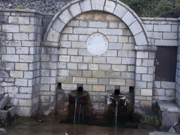
Around the current Ano Karyes (Karyes), there are several springs sparkling crystal clear waters that sweep away the thirst of every passerby, local and foreign, who is fortunate to find in the water springs. The village is mountainous and beautiful and is drowned in the green with walnuts, cedar, oak, white, pine, fir, holly, mulberry and fruit trees.
Apart from the four-year period Panarcadia Lykaia is celebrated and celebrated on the 20th of July of Prophet Elias, where it celebrates the beautiful chapel next to the ancient marbles of the holy peak of the Arcadians and where the village and all round chips and shepherds offer free boiled goats, local cheese, bread and pure wine. Also every year, the last Saturday (All souls day) before the Pentecost and the Holy Spirit, there is the old custom called “On Rousaliou on Saturday” where religious, social cultural and very beautiful folklore events take place.
The sights in and out of Ano Karyes are many and interesting.


Starting from our villa, driving for 15 minutes and after 8 km distance, passing the picturesque villages of Lykaio and Lycosoura, you will come across a sign that will take you to the archaeological site and the museum of Ancient Lycosoura that can be visited for you. We advise you to call before you begin to ask about the working hours of the archaeological site.
Phones
Archaeological site of Lykosoura: +302791025780
Ephorate of Antiquities of Arcadia: +30 2710 225 243, +30 2710 242745
Φαξ: +30 2710 242 227
To the south of the Prefecture of Arcadia, 15 kilometres from Megalopoli lies Lycosoura, where there is also an archaeological site dedicated to Despina, daughter of Demeter and Poseidon, and one of the most important deities worshipped in Arcadia. Within the archaeological site a Museum was built, which was intended to house the findings that would be brought to light by the excavations that had begun in 1903 by the Archaeological Society.
Inside the sanctuary of Despina stood the colossal complex of Damophon, which represented Despina and Demeter seated on thrones and surrounded by Artemis and the Titan Anytus. Fragments from this complex’s statues comprise the Museum’s main exhibits. Most of them are faithful reproductions, since the originals are displayed in the National Archaeological Museum. Originals that are displayed in Lycosoura include fragments from the complex’s podium, with their relief decorations. Apart from those, the Archaeological Museum of Lycosoura houses marble and clay votive offerings, inscriptions, sculptures, as well as various other small findings.
The Archaeological Museum of Lykosoura is a small museum situated in the Lykosoura region of Arcadia, very close to ancient Olympia and Megalopoli. According to mythology, the founder of Lykosoura was Lycaon. Pausanias refers to it as the first city to be built in Arcadia, which was in fact a model for the others that followed.
Lykosoura has many noteworthy monuments. One of them was the temple of Despoina, the daughter of Demeter and Poseidon; her cult being one of the most important in Arcadia. According to the myth, when Demeter was wandering in search of Persephone, her lost daughter, she reached Arcadia. Poseidon saw her there, fell madly in love with her and went after her. In her efforts to escape, Demeter transformed into a mare, and hid in a barn. Poseidon, however, also transformed into a horse, coupled with her and thus Demeter gave birth to another daughter, her name not found in any source. The Arcadians, however, called this daughter Despoina and worshiped her with special honours in this region. The temple they built in her honour is proof of the particular respect they showed towards this deity.
The sanctuary that contained the temple also contained an altar to Despoina, Demeter and other deities, as well as a large stoa, a fountain, remains of baths and other buildings of a religious nature, dating to the 2nd century BC. The Archaeological Museum was built within the sanctuary’s archaeological site and was created to house the antiquities coming to light from the excavations, including marble and clay votive offerings, inscriptions, sculptures, as well as various other fragments, both from the sanctuary of Despoina and the Sanctuary of Zeus on Mount Lykaion. The most important exhibits of the museum come from the colossal marble sculpture complex, attributed to the famous Messenian sculptor Damophon. This complex was found inside the temple, and depicted Despoina and Demeter sitting on a two seated throne, surrounded by Artemis with a hound, and Anytos, the Titan who brought up Despoina. Original fragments of this complex are exhibited today in the National Archaeological Museum of Athens. Copies of the heads of the statues of Demeter and Artemis and Anytos are on display in Lykosoura, as well as part of the sacred clothing of the gods. The only original fragments exhibited in Lykosoura are from the complex’s pedestal. There is also a whole representation of the complex in the museum as well as inscriptions and architectural parts of the temple and other buildings of the sanctuary.
Excavations in the sanctuary started in the late 19th century, when the temple was discovered at the location known as “Paliokastro tis Stalas”. At the beginning of the next century, archaeologist Kostas Kourouniotis and his team brought to light fragments of the Damophon complex, and the Archaeological Museum was built a little later, an important addition to this region, which is rich in evidence of a glorious civilization that peaked here many centuries ago, its flame, however, still burning to this day.
After you compensate for the archaeological site of Lycosoura, you can take the road leading to the picturesque village of Issaris. Driving for about 30 minutes more and after 20 km, you will pass the village of Issaris and you will reach the wonderful church of Aghia Theodora. There you can, after worship, drink your coffee or eat next to the wonderful church enjoying the beautiful nature.
Church of Aghia Theodora ( Telephone : +302791081343 )

The miraculous small church of Aghia Theodora is located near the village of Vasta, in Megalopoli, and is one of the most remarkable sights in Arcadia. Situated within a beautiful, green landscape, many times it has been called “a miracle of nature”: from its roof spring out 17 trees, whose roots penetrate the walls and end up in the ground!
This natural phenomenon is connected with a legend regarding the holy martyr Theodora, to whom this small church is dedicated: Theodora, a seventeen-year-old girl, was forced to leave her home and enlist in the army dressed as a young boy, in order to help her family out financially. A series of events, however, led to her martyric death outside her village. Her last wish, before she died, was for her years to turn into trees and for her blood to become their water. And so it happened…
This remote small church, built in the 12th century, attracts thousands of visitors each year, who come to pay their respects and also to admire this unique sight.
The region of Arcadia is brimming with churches and monasteries, evidence of the deep faith of its inhabitants, which served as a driving force during difficult times in the past. Each one of them has its own particularity, at least in the minds of the people who built them with deep faith and love. There are however others, which are “miracles of nature”, filling the visitor with awe for the glory of nature… One of these is the Church of Saint Theodora, close to the village of Vasta, in Megalopoli.
To reach it, visitors must start out from Tripoli, on the road towards Kalamata. Around ten kilometres past Megalopoli, one must turn towards Isari – Vasta, and then follow the last kilometres to reach the destination. The last part of the road, taking approximately half an hour, needs attention, because it has many turns and a steep descent; but at its end a unique view is waiting for the visitor. Inside a dense oak forest stands a small church, with 17 enormous trees growing on its roof. Under the church there is a stream that waters the trees, which have been standing there for centuries.
It is estimated that the church was built circa 1050 and 1100 AD, and is dedicated to the memory of the martyr, Theodora, who suffered there for her faith. According to tradition, the young Theodora was the eldest child of a poor family from Vasta. The Byzantine army was asking for mercenaries, but her father was elderly and could not take part in battle. Thus Theodora wanting to help her family financially, and enlisted in the Byzantine army dressed as a boy, calling herself “Captain Thodoris”. A young girl saw the “young soldier” and fell in love with him, not realizing his true identity. The continuous refusal of the soldier to respond to her love enraged the girl, who accused “him” of getting her pregnant, so that he should marry her. Theodora, being unable to reveal her true identity – because this would expose her family – accepted the severe accusation of dishonour, which led to her death.
According to another version of the story, Theodora was Augusta Theodora, daughter of Emperor Constantine VIII, and scion of the Macedonian dynasty, who is said to have reigned as a man for one year, in 1055-1056. Theodora was succeeded to the throne by Michael IV Stratioticus, who is said to have murdered her. According to another version, Theodora fell gravely ill and died.
Whichever of the two versions we accept, the story ends with Theodora making a wish shortly before she is executed that her years become trees and her blood water, to water them. Her wish was heard, and as a result the visitor today faces a unique phenomenon, one that ranks the Church of Saint Theodora amongst the most remarkable sites of Arcadia, actually entered in the Guinness Book of Records. The church celebrates every year on the 11th of September, attracting a number of believers.
Starting from our villa, passing the picturesque villages of Lykaio and Lykosoura, Apiditsa and Choremi, you will come across a sign that will guide you to the picturesque village of Leontari. Driving for 45 minutes and after 30 km you will reach Leontari. In the beautiful stone-built central square of the village you will find the Holy Temple of the Saints Apostles. You can also visit the village castle and then take a stop for coffee or food in the picturesque central square.
Holy Church of Aghii Apostoli, Leontari
Twelve kilometres from Megalopoli lies the picturesque village of Leontari, in the central square of which stands the Holy Church of Aghii Apostoli. It is a Byzantine church of the mixed type; on the ground floor it follows the configuration of a three-aisled basilica, while on the top floor it is a four column domed cross-in-square church.
Based on the architectural elements, the church has been dated to the 14th century A.D. In the following centuries it went through many changes, and it was even converted into a mosque, during the Turkish rule. The church underwent many changes after the liberation also, which significantly altered its original form. Today only the western side of the initial church remains, as well as the southernmost of the Byzantine arches. The two consequent ones were created after the Turkish rule, while the northernmost one is a much later addition
The scenic and historical village of Leontari, in the prefecture of Arcadia, is located around 12 kilometres from Megalopoli. During the Frankish domination it belonged to Veligosti, one of the most important baronies in the Peloponnese, and became a major commercial and administrative hub of the entire region, due to its strategic location. There are visible remnants of a Frankish castle on a hill that rises above the village. There are many Byzantine churches in Leontari, the most important of which is the church of Agioi Apostoloi, a remarkable example of Late Byzantine architectural design located in the main square of the village.
This church was built in the 14th century and is of particular importance, as it combines two architectural styles, something that occurs in very few religious monuments. The ground floor was a three-aisled basilica, while the first floor has the layout of a domed tetrastyle cruciform church. This mixed style first appeared in the area of Mystras and it characterizes the so called Palaiologan church architecture. The first structure built according to this style was the main church of the Monastery of Vrontochio (widely known as Odigitria) and was later also used for the churches of Pantanassa, of Agios Dimitrios, and for the Cathedral of Mystras. The church of Agioi Apostoloi was the first one, outside of Mystras, built according to this specific mixed style, something that makes it extremely interesting.
Over the centuries there have been numerous interventions in the church, and during the Turkish domination it was converted into a mosque and its bell tower turned into a minaret. Today, only half of the tower is still preserved. Even after the liberation of Greece, the church underwent yet more changes, which significantly altered its initial form. Nevertheless, it remains one of the most intriguing religious monuments of the wider region.
Next to Leontari and on the hill that dominates the village, there are the ruins of a medieval Frankish castle. The region belonged to one of the most important Frankish barons of the Peloponnese, called Veligosti. His strategic position has made Leontari during the Frankish occupation a commercial and administrative center of the whole region.
Leontari developed rapidly after the Veligosti disaster. Indeed, from 1300 to 1391 he was the seat of the deserters of Morea. In 1391 he was captured by the Turks under Evrenoz Pasha. Soon the Turks left and the Leontari returned to the Byzantines.
In the castle are remnants of the fortification and a reservoir. Close to its entrance there is also the interesting Byzantine church of Agios Athanasios, a typical example of Byzantine architecture.
His great glories, however, seem to have been known to them in Byzantine times, since he was not only a thriving Greek community that succeeded the Frankish settlement of Veligoris, but over the years he developed into the second most important city of the Despotate of Mystras, while for a limited time intervals claimed the title of his capital, around 1391, due to the strategic position of his famous castle.
This fort was also the main reason Leontari did not lose its glory, nor in the years following the Fall of Constantinople, as both the Venetian conquerors and the Turks collided several times in their attempt to put it under their own and regardless of the power that the settlement held, it maintained the title of the homonymous province.
Its strategic importance was so great that for a period of time it was transformed into the seat of the Turkish Pasha of the Peloponnese, and later, after the finalization of the Turkish rule in the Peloponnese, Leontari continued to hold the capital of one of the 24 provinces – vilatia, in which the conquerors divided Moria.
Indicative of the importance of the castle for the owner of the area is that the salary of his guard was made directly by the sultan himself, a tactic applicable to the important fortresses, such as those of Mystras, Nafplion, Patras, Navarino , Methoni and Koroni.
Since you are natural and religious you can visit 3 very beautiful monasteries, the Monastery of Bouras, the Monastery of Rekitsas and the Monastery of Ampelaki “Dormition of the Virgin” located very close to Leontari. Be sure that the nuns and monks you meet will welcome you, will treat you and guide you to the places of worship of God.
Then you can dine in tavernas in the villages of Leontari, Potamia, Kamara, Akovos, Dyrrachi.
Bouras Monastery is located near the village of Leontari (6 km), next to the Leontari-Sparta road. It is built on a verdant hill, 4 km from the village of Falesia and is dedicated to the Assumption of the Virgin Mary.
Although the exact date of construction of the monastery is not known, it is probable that it was built in the middle of the 12th century. Since then it has been a monastery. The pre-revolutionary years, as well as the period of the 21st Revolution, have been the cradle of the struggle for liberation.
Pyrgos, a building of the Monastery of 10 meters, is with its cloaks the testimony of the monks’ resistance against the Turks.
In the 1770 revolution the monastery was plundered by Turkish-Albanians who killed all the monks and destroyed the murals.
Later, at the Ibrahim invasion, the monks made bold resistance against the Turks until they were all killed.
In 1932 the Monastery was annexed to the Monastery of Timios Prodromos and was closed. In 1934 he reopened with a few nuns who came from the nearby Monastery of Ambelaki.
In 1952 her property was given to the landowners of the Falesia, and since then it has begun to decline. In 1984 a group of nuns settled, who during 15 years preserved and reformed the Monastery, renovating its old buildings and creating new buildings.
Among the latter are the beautiful church of Agios Alexios, the temples of Agioi Anargyroi, Raphael, Nicholas and Irene and the two-storey building that houses the cells, various workshops, the library and other places.
The monastery celebrates on August 23rd.
The Monastery of Rekitsa is a monastery located in the Arcadian Taygetos, 7 km north of the village of Dyrrahi. The monastery is located at an altitude of 1,100 meters, on the edge of a fir forest.
The monastery was, according to written testimonies, before 1600 AD. where a multitude of monks exercised in it. He was the leader of the armatals and thieves during the Ottoman domination.
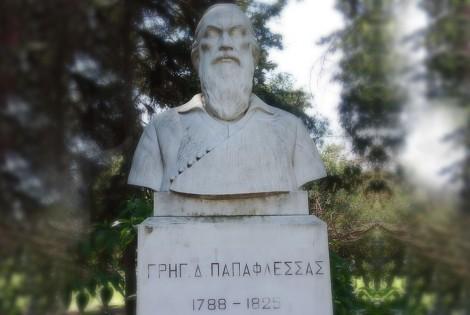
There he was for a few years the hero of the Greek Papaflessas revolution. The monastery was destroyed by the Turks several times and was arrested.
On August 16th, a local celebration takes place with a host of people and authorities.
Today, the monastery stands abandoned, with the ruined cells and only the church of the Virgin Mary in good condition.
The Exodus of Papaflessas – The Celebrations in Dyrrahio
Papaflessas, also known as Grigorios Dikaios, was a cleric, a politician and a great hero of the Greek Revolution. Initially he lived in the Monastery of Velanidia, outside of Kalamata, but then went to Istanbul, where he was ordained an Archimandrite and was later initiated into the Filiki Etairia (Society of Friends). He came back to the Peloponnese during the particularly turbulent time that preceded the Revolution, with the aim of encouraging the people. His base was the Monastery of Rekitsa, near Dyrrahio, which he used as a starting point for many decisive battles in various locations in the Peloponnese and especially in Arcadia. Papaflessas was killed in the battle of Maniaki on May 20th, 1825, after fighting heroically on the side of the very few comrades he was left with.
The exodus of Papaflessas from the historic Monastery of Rekitsa is annually celebrated in Dyrrahio, under the auspices of the District of the Peloponnese, the Municipality of Megalopoli and the Brotherhood of the Dyrrahians of Attica. The entire village is filled with flags and the celebrations start with a Doxology in the Monastery of Rekitsa. Then the officials are gathered in front of the statue of Papaflessas, where a memorial service is chanted, followed by a wreath laying, a minute’s silence and the standard celebratory speech. After that the officials are awarding the prizes to the athletes that ran the Dyrrahio – Rekitsa race and the celebrations end with the National Anthem.
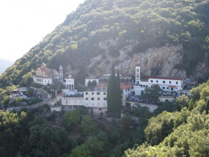
In the middle of the ravine is a cave. On the right and on the left, the peaks of a rock are pierced by the sky; one cross rises to one, and on the other one the Ascension Temple.
In the interior of Spilia, the icon of Virgin Mary, called “Virgin Mary Makelaritissa”, was found and is considered one of the seventy Images of the Apostle and Evangelist Luke!
It is speculated that a monk – a possible Athonite – after the destruction of his monastery by the Turks, he took the specific image and, after persecution, found shelter in the Cave.
Later, Asheti’s bones were found there and today they are kept behind the Holy Tomb of the Ascension Temple. Around the cave, a small vine spreads out of it, and the inhabitants know the area called “Ambelaki”, so its name took its name.
The Monastery celebrates on September 8th and every year a number of believers arrive to worship the image of “Our Lady of Makelaritissa” considered to be miraculous!
The treatment of paralysis, cerebral pain, epilepsy, infertility and many more are among the wonders … In the front door of the Monastery and at the top, the image of Our Lady of Portaitissa follows the incoming …
At the center stands the Temple of Ascension, inaugurated by Bishop Lakedaimon Theodult, later Archbishop of Athens and all Greece!
He also ordained the first Monk, the Monk Pelagia. Outside the Temple, the visitor conquers the Crucifixion and the tomb where the Bones of the Monastery are kept.
In the courtyard of the Monastery, Hero “for the fallen” has been raised in battlefields. A little further, we can also visit the chapel of St. Demetrius of Myroavitis.
Also, when we enter the Monastery, we also come across the Church of Saint Nektarios. On the rock-section – there is the Church of Saint Savvas, the confessor of monks and pilgrims.
The entire Monastery is supplied with water from a spring that springs to the east side of the peak. Regarding the hospitality of the visitors, we have to say how it works, which can accommodate up to 200 people! But for the visiting priests there is a room in front of the Ascension Temple.
The Holy Monastery of the Birth of the Virgin in Ampelaki is under the spiritual protection of the Seb. Metropolitan Gortyn and Megalopolis Mr. Theophilos.
It hosts nine nuns and Gerontissa, the Pelagian Monk.
Access to the Monastery is by bus or taxi. Coming from Athens through Tripoli, we pass Megalopolis and Leontari to reach the village of Falassia and then to the Monastery (approximately 250 km).
Tripoli is 50 km away and other Sparta.
Starting from our villa and arriving after a few minutes in the picturesque village of Lykeo, you will come across a sign that will guide you to the archaeological site of Apollo Epicurius, the Parthenon of the Peloponnese. Driving a total of 45 minutes and 24 km away, passing the picturesque villages of Neda, Ambeliona and Agios Sostis, you will reach the archaeological site of Apollon Epicurius which can be visited for you. We advise you to call before you begin to ask about the working hours of the archaeological site.
Phones
Archaeological site Apollo Epicurius : +302626022275
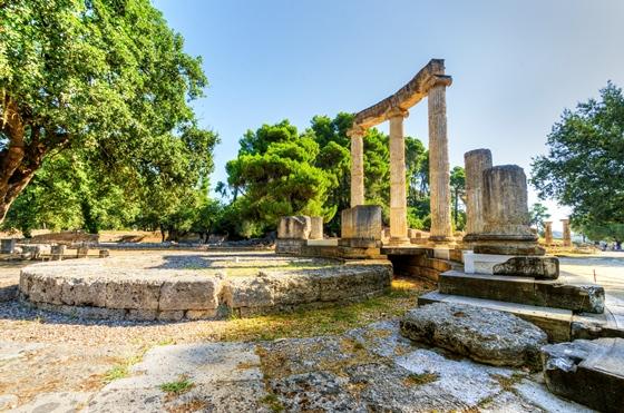
Temple of Apollo Epikourius
In the ancient Arcadian city of Figalia stood one of the most imposing temples in antiquity, dedicated to Apollo Epikourios. The locals erected this temple as a gesture of gratitude to the god, for protecting them during a plague epidemic. The name “epikourios”, after all, meant “helper”.
The temple was located in Vasses and was founded on the natural rock of mountain Kotilio. Around the 7th century, there used to be an older temple of Apollo Vassitas here, which also went through later phases, as various findings testify. In its final phase, the temple was built during the second half of the 5th century B.C. and it is attributed with much probability to Ictinus, the architect of the Parthenon.
The temple of Apollo Epikourios was famous for its beauty. For its decoration a great variety of materials and styles were used, while the frieze impresses with the representation of the scenes and the mobility of the figures. The importance of this temple is evident by the fact that it was the first monument of Greek classical antiquity to be included in the list of UNESCO’s World Heritage Monuments.
A particularly impressive temple dedicated to Epicurean Apollo is located in Vasses of Figaleia, an ancient Arcadian city in today’s prefecture of Ilia. The temple stands at an altitude of 1.130 metres onto the natural rock of Mount Kotilio as a reminder of the help (Epicurean) the God provided to the locals when they were threatened by plague.
The Temple of Epicurean Apollo dates back to the second half of the 5th century BC and is quite possibly a creation of Iktinos, who, of course, was the architect of the Parthenon. It is one of the most impressive monuments of the ancient world, not only because it is exceptionally well preserved, but also because of its unique beauty, which was praised even since antiquity. The traveller Pausanias, who visited the temple several times, said he was truly impressed by its beauty and harmony.
The temple boasts an exceptional combination of archaic, classical and traditional Arcadian features. The outer colonnade is of Doric order, while its interior boasts a more complex sculptural decoration. There are two columns in a row in its narthex and rear room, making this temple of Doric order and distyle in antis. In its nave there is a range of fitted Ionic columns, while a Corinthian style one stands alone, between the two last Ionic columns near the sanctuary. The capital of this lonely column is considered the oldest preserved example. This temple stands out compared to others of the same period also because it was oriented from north to south, something which was probably associated with the worship of the Arcadians, since this orientation can also be seen in other temples of the area.
The systematic excavations that started in 1812 brought to light the Corinthian capital, as well as part of the frieze, which since 1815 has been housed in the British Museum. This frieze, located inside the nave, included two re-enactments: the battle between the Greeks and the Amazons and the battle between the Lapiths and the Centaurs, a theme frequently seen in ancient Greek decoration. In the following century there were more intense archaeological excavations, which offered a more complete image of the monument. In 1982 the Ministry of Culture ordered its restoration, deemed necessary since climatic and geological conditions constitute a real threat to its structural integrity.
This famous temple to the god of healing and the sun was built towards the middle of the 5th century B.C. in the lonely heights of the Arcadian mountains. The temple, which has the oldest Corinthian capital yet found, combines the Archaic style and the serenity of the Doric style with some daring architectural features.
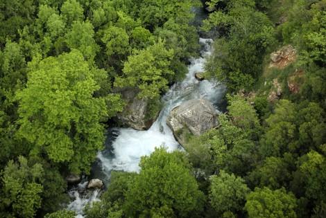
After departing from the archaeological site of Epicurius Apollo, driving for 30 minutes and after 16 km you will see the waterfalls of Neda where you can enjoy strolls in the beautiful nature and cool in the crystal clear waters.
Neda is the only “female” river in Greece. It stems from the foot of Mount Lykaion and flows into the Ionian Sea, more specifically into the Kyparissiakos Gulf. Neda is approximately 32 kilometres long and passes through a stunning fairytale-like landscape.
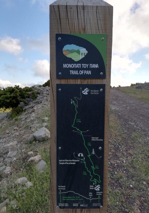
The Valley of Neda was of particular importance to the ancient Greeks and was often mentioned in various myths, while it is surrounded by archaeological remnants. A unique temple, dedicated to God Pan, is located here, while the majestic temple of Epicurean Apollo –a creation of Iktinos– is located in Vasses.
The gorge of the river is equally intriguing and dazzles visitors with its stunning wild natural landscape. The best time to cross it is from May to September, provided it doesn’t rain. Entrance to the gorge is possible at many points, depending on the length of the route one wishes to cover. Nevertheless, the entire route is approximately 20 kilometres long and it would take two days to cover it. Proper preparation is necessary, since beyond its undoubted beauty, the gorge does have several points that require extreme caution.
Leaving this little paradise behind you, returning to Epicurius Apollo and driving for 50 minutes, after 30 km you will find the very beautiful hamlet of Andritsena. You can make a stop to browse and sit for coffee or food in the picturesque central square of the village, as well as visit its public historical library and folk museum.
Andritsaina is a medieval town, built at 760 m of altitude in the foothills of Lykaion mountain, while its first records as a settlement date approximately from 900 AD. Its name comes from the beautiful widow of Andrikos Mourmouris, Antrikaina (or Andritsaina as it is pronounced in the local accent), who owned a “hani”, an inn for travellers to rest, (“Hani tis Andritsainas”), around which the first neighbourhood of Andritsaina was built, Mourmoureika, where the “Trani Vrysi” fountain is now located. Eventually (by the Frankish-Venetian rule period) the neighbourhood expanded and became a small town, which at its peak included about 20 neighbourhoods.
In 1800, Andritsaina was an important “hora”, a county seat, with many buildings, workshops and commercial activities. It played an important role both during the Orlov revolt, paying a high price in sacrifices and during the Greek Revolution. In fact, in 1826, the town was destroyed (burned) by Ibrahim’s troops.
During the interwar period (1924 – 1940) Andritsaina developed great commercial, intellectual and tourism activities (thanks to its proximity to the temple of Apollo Epicurius), which continued after the end of World War II for several decades. This is evidenced by: the operation of the Primary and the Hellenic Schools first and then the Secondary (Gymnasion) and High (Lykeion) Schools, the Nikolopoulios Library in the north-east wing of the School, the Vocational Schools (teaching Carpet-making, Cheese-making, Sewing, Dancing, Olive Tree Pruning and Grafting), the existence of various shops and businesses, local newspapers, associations and clubs, the implementation of several Public Services. The most important trade event in the region was Andritsaina’s fair, reaching its peak in the 1950s.
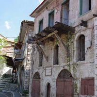
Nowadays, the town is the historic seat of the municipality of Andritsaina-Krestena, while it was formerly the seat of the Kapodistrian municipality of Andritsaina. It will enchant you with its stone mansions, cobbled streets and the central square with its tall trees and magnificent views.
SIGHTSEEING IN ANDRITSAINA
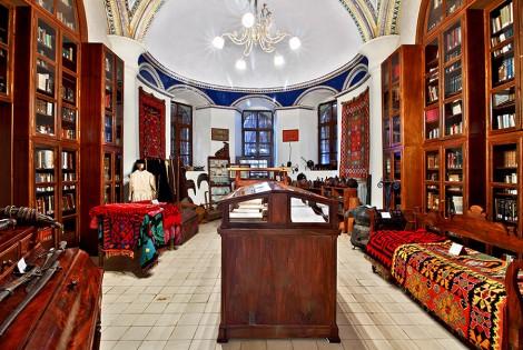
Public Historical Library of Andritsaina (see Historical data)
Historical High School of Andritsaina
In 1875, the erection of the School of Andritsaina began in a plot offered by Nikolis Mpampadimos, designed by Miltiades Kanellopoulos – Engineer and Professor of the Military Academy – in a U-shape, open on the north-eastern side. The necessary funds came from a nationwide fund-raiser and a donation by Angelos Giannikesis, Consul of Greece in Trieste. The building was inaugurated in 1879. The School building housed the Primary School on the ground floor, the Hellenic School on the first floor and the Nikolopoulios Library in the west wing of the first floor. Among the first Secondary Schools in Greece, the Gymnasion was founded in 1882 and started operating in 1889 (1st Grade).
The NE wing was built in 1932, as an annex to form the building as we know it currently.
Folklore Museum of Andritsaina
The Folklore Museum of Andritsaina was established in 1981 on the initiative of the “Women’s Cultural Association”. The Association’s initiative was reinforced by the immediate response of Andritsaina residents, who gathered and offered remarkable traditional artefacts. The Museum was originally housed in the home of Vangelis Theocharis (next to the OTE building) and then in the Kanellopoulos mansion, offered by Galini Kanellopoulou for this purpose.
Stone buildings – Paved streets
Churches – Chapels
Fountains-Theatre
After a busy day with beautiful pictures and moments, the road of returning to our villa is inevitable for relaxation and relaxation. Driving for another 55 minutes and after a 29 km distance you will reach our villa, after taking the opposite course and reaching the village of Lykeo, turn left towards the village of Ano Karyes.
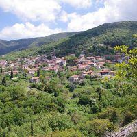
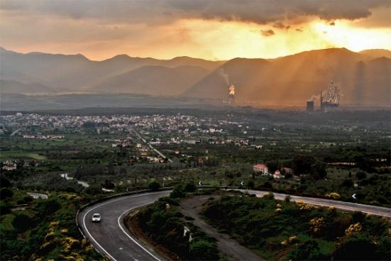
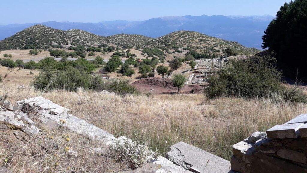
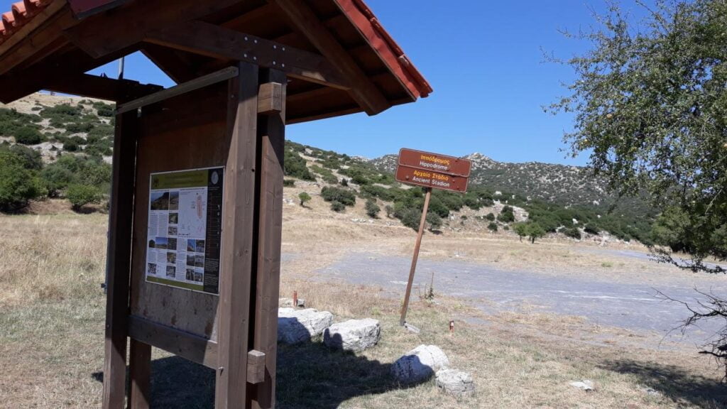
Starting from our villa, driving for 30 minutes and after 18 km, passing the picturesque and amphitheatric village of Kastanochori, the villages of Kato Karyes and Thoknia, you will reach the capital of the local Municipality, Megalopolis, which hosts one of two energy centers in Greece. There you will find a sign that will take you to the site of the Ancient Theater of Megalopolis, which is open to you. We advise you to call before you begin to ask about the working hours of the archaeological site.
Phones
Of the Municipality of Megalopoli: +302791360200
Ephorate of Antiquities of Arcadia: +30 2710 225 243, +30 2710 242745
Fax: +30 2710 242 227
Also in Megalopolis you will find an organized market for your shopping, for your banking transactions, for your medical or pharmaceutical needs. You can finally make your walk in the city and have your coffee in the beautifully landscaped central square.
Megalopolis and Antiquities
Megalopoli, one of the most important cities of the prefecture, has its own contribution to the history of the region. It was built in 370 BC. by order of Thebes Epaminondas. Pausanias in “Arcadia” says that the theater was the largest in Greece.
It was in the antiquity a cultural and spiritual center that helped to cultivate the Arcadians spiritually. Even today, the splendor of the majestic ancient era keeps alive. The continuation of the theater was the stadium for athletic competitions. It is estimated that 18 and 20 thousand people could sit there. Excavations of the British Institute brought to light the sun, the orchestras, the presidencies, the lower stone stables of the theater, the lifts of the lanes and the foundations of “Thersilio”, which was adjacent to the theater.
The “Thersilio” was the parliamentary chamber of the Arcadians, the famous House of Myrion, in which representatives of all Arcadian cities took part. His name was taken by Thersilos, from Orchomenos, and symbolizes the idea of the unity and democratic rule of the peoples. The existence of this building proves the profoundly democratic nature of the Arcadians, their free thinking, elements that have significantly influenced the entire later civilization of the region, but also the culture of the whole of Greece.
Megalopolis – The Great Town of Arcadians
At 35 km from Tripoli, you will meet Megalopolis built in the same place as the ancient Great City of Arcadia, which was founded by Thebes Epaminondas after the defeat of the Spartans in 371 BC. in Lefktra with the merger of 40 Arcadian cities.
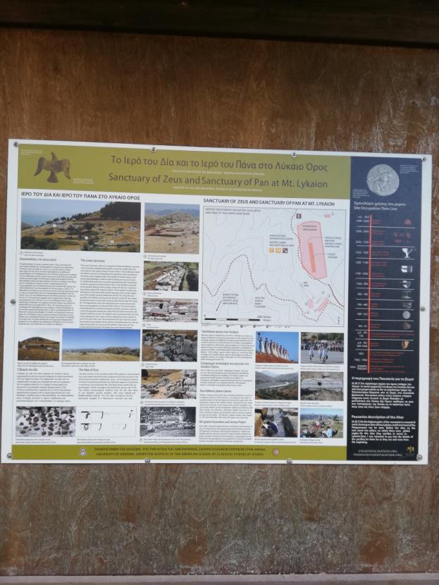
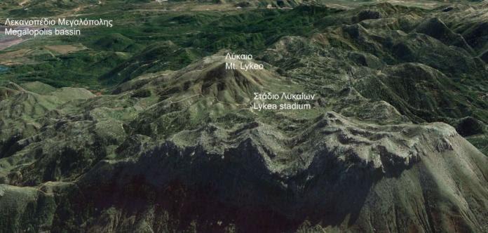
The tour of the archaeological site and the Archaeological Collection near the river Elison is a truly impressive experience worth exploring. You will meet the impressive ruins of the Thersilio Boulevard, the ancient market, the sanctuary of the Zeus and Zeus of Lykaios, the Philippi Stoa and one of the largest theaters of antiquity, which could include 18,000 spectators.
Near the Megalopolis dominates the PPC power station that exploits the lignite deposits. This energy center was raised on the plateau in 1965, and although a large part of the population is employed at this station, environmental destruction, abandonment of settlements and population migration remain problems seeking solutions.
A commercial pulse surrounds the central square of the city, while the ecological park, the Cultural Center, the Cultural Association and the large international Moto Cross are adding cultural and sporting activity to the state.
Starting from Megalopolis, visitors can follow paths for naturalistic and archaeological visits in the surrounding area, which are rich in sightseeing. So, you can visit the Monastery of Panagia (or Agia Moni), the treasure of Theodoros Kolokotronis, or take the road to Karyes passing from Marathousa, Thoknia, with the temple of Saint Demetrius with wall paintings of 1730, as well as the historic Kastanochori.
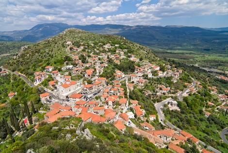
Arriving in Ano Karyes at an altitude of 1,050 m, in Lykaio Mountain, the old watermill, the library, the many springs, the spiritual center and the Museum of Folk Art testify to the bustling past of the settlement, which comes alive with the custom of “Roussaliou” Saturday “before the Pentecost, but also with the revival of the” Lykaeon “in the nearby ancient Lykosoura.
In the sacred peak of Arcadians, the ruins of the archaeological site of the sanctuary of Lycaeus Zeus and ancient Lykosoura, with the sanctuary of Demeter and Despina, resemble “something” from the ancient mystic feasts. The road continues to the historic village of Issari, the Chrani with the trains, or on the other side of the main public road to Veligosti, in the place of the important medieval city and the important medieval settlement of Leontari, built in the time of the Komnenoi village today beautiful stone-built, with a castle and magnificent Byzantine churches.
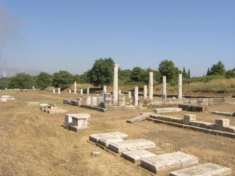
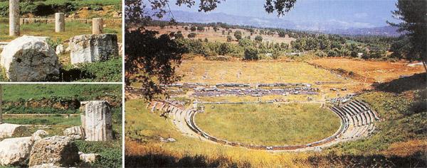
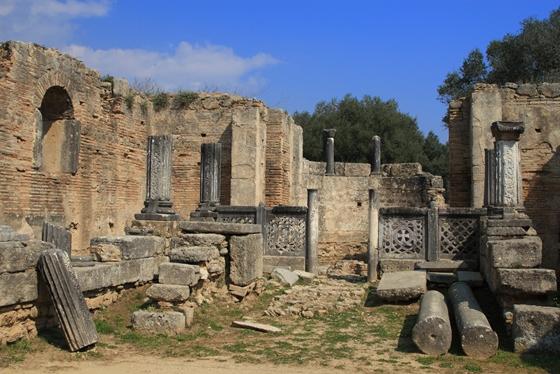
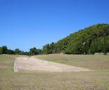
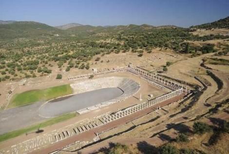
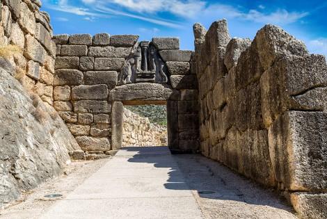
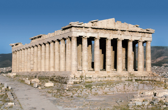
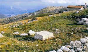
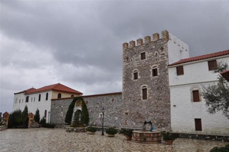
Ancient theatre of Megalopoli
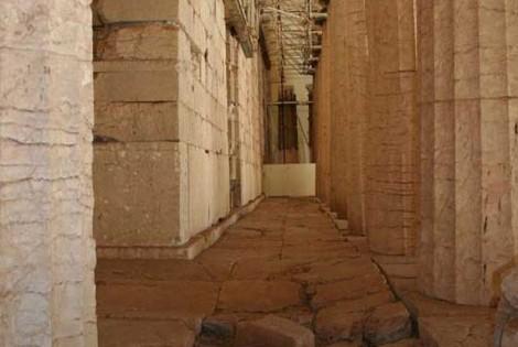
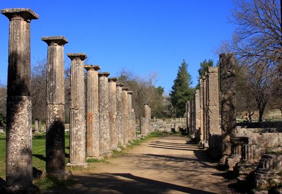
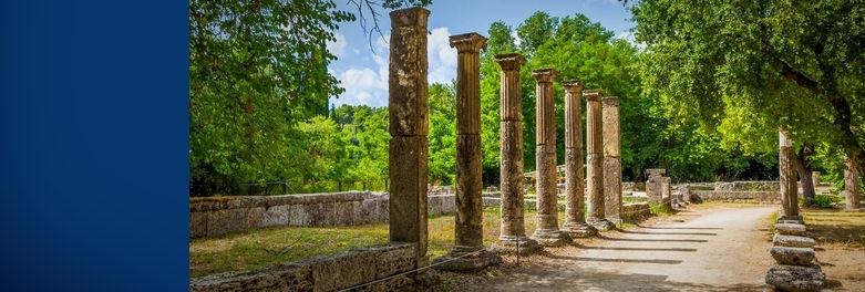
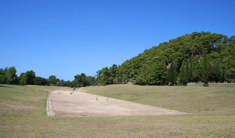
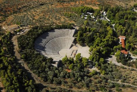
The ancient theatre of Megalopoli is situated within the archaeological site of Megali Polis (“Great City”), one of the most splendid, but unfortunately short-lived, cities of Arcadia. It was the largest theatre of its time, with a capacity of approximately 20,000 persons, and apart from theatrical performances it also hosted the assemblies of the representatives of the 40 Arcadian cities that were annexed to Megalopolis.
The theatre was constructed by Polycleitus from Argos around 370 B.C. Its koilon had a diameter of 145 metres and included two diazomata, with 17 rows of seats on the upper part and 20 rows on the lower two parts. Its orchestra had a diameter of approximately 30 metres. Around the 19th century came to light the orchestra, the proscenion, part of the prohedria, parts of the stone cunei, the analemmata of the parodoi and the foundation of the scenotheca. Apart from its size, this theatre also boasted about its excellent acoustics.
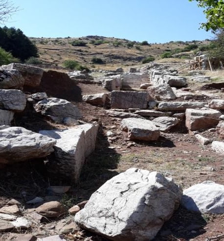
Three kilometres outside modern-day Megalopoli, in close proximity to the road leading from Megalopoli to Karytaina, lies the archaeological site of Megali Polis, one of the most magnificent cities of ancient Arcadia which, despite this, did not manage to survive for more than two centuries. The archaeological site contains ruins of the ancient agora, the Thersileion parliament hall on the north side, with a capacity of approximately 16,000, as well as the largest and oldest theatre of Ancient Greece, situated across from the agora and connected to it by a bridge.
The theatre was constructed by Polycleitus of Argos, circa 370 BC, and had a capacity of around 20,000 spectators and perfect acoustics. The reason its proportions were so large was that, in addition to theatre, it also hosted meetings of a political nature between the 40 Arcadian cities that comprised Megalopolis, which could be attended by any interested citizen. A wooden stage with wheels was used for plays, which was kept at the scenotheque (the stage store) and would be pulled out to the theatre whenever needed. The theatre’s peak is placed in the 3rd century BC, and coincides with the peak period of Megali Polis.
The theatre first started to come to light in the late 19th century. The British Institute started excavations in the region in 1890-1891, which revealed the proscenium, orchestra, part of the proedria, the analemma walls of the parodoi, the foundations of the scenotheque and the lower stone seats. Research is still underway at the Thersileion parliament hall site, and new results are expected.
The ancient theatre of Megalopolis is part of a European programme financed by UNESCO. The goal is to carry out the necessary restoration works that will further highlight the importance of this ancient monument.
After your visit to the capital of the Municipality that owns our village of Ano Karyes, where our villa is located, you can take the road to the picturesque and preserved village of Karytaina. Driving for 20 minutes and after 19 km distance, passing through the villages of Katsimbali and Karvounari, you will reach the beautiful Karytena.
We recommend that during this trip you can make a stop at the Panagia Karvounareiki for pilgrimage and a stop at the “Papakia” multifunctional complex that has a remarkable private zoo and can give you moments of relaxation at all ages. It features a playground, café and food.
In Karytena, we suggest that you take your walk on the paved alleys and climb up to its castle. Here you will find choices for coffee and food. Finally, you will start with the rafting car for your boat ride on the river Lousios.
If you do not want to do rafting, driving a few minutes after Karytena, you will find the river Lousios in the Atsicholos bridge. There, a walk alongside the river will compensate you.
Karytaina
Picturesque and historic Karytaina is located a few kilometres south of Stemnitsa and is one of the more impressive, well preserved and listed settlements in Arcadia. Crowned by an imposing Frankish castle that played a significant role during the Greek Revolution, Karytaina is surrounded by the pristine Arcadian natural landscape, rivers Lousios and Alfeios and it’s not far from Lykosoura, which is the most significant ancient Arcadian temple. During the Turkish occupation Karytaina became a commercial hub for tobacco, silk and wine, while today the two-storey stone houses, the numerous Byzantine churches, the once operating watermills, the fountains, the incredible stone bridges and the remnants of the castle all create a unique Arcadian scenery. Around Karytaina there are many smaller mountainous villages, like Kalyvakia, Karvouniaris, Kastimbalis, Mavria, Kyparissia, Kourounios, Atsiholos, Vlahoraptis, Sarakini, Palaiokastro; each with its own unique beauty.
The historic and picturesque Karytaina, a few kilometres south of Stemnitsa, is one of Arcadia’s most impressive preserved settlements. Sturdy, two-storey stone houses, plenty of remarkable Byzantine churches (Zoodochos Pighi, Aghios Nikolaos and others) which you come across as you wander along the cobbled alleys, going as far up as the castle –where the panoramic view to the valley is spectacular– and also to its top, where you will find Panaghia, also known as the church of Kolokotronis, domed stone fountains, fragments of water mills that used to operate in the area, all of them constitute the unique, but at the same time familiar, beauty of Arcadia.
Karytaina is crowned with an imposing Frankish castle, reminiscent of its significant role during the Frankish rule; during the Ottoman rule it also became a centre for the trade of tobacco, silk and wine, without forgetting, of course, its active participation in the Greek Revolution. Surrounded by virgin landscape and chiseled by the rivers Alpheus and Lousios, it stands close to the most important ancient Arcadic sanctuary, Lycosoura. There, on the holy summit of the Arcadians, where history intersects with myth, on mountain Lykaion, stand the ruins of the ancient Arcadians’ holiest city, as well as the remnants of the sanctuary of Despina, daughter of Poseidon and Demeter. The sanctuary’s colossal statues, works of the sculptor Damophon (2nd century B.C.), are kept at the Archaeological Museum of Athens.
An abandoned two-storey tower-shaped house, dating to the 15th century, a five-arch stone bridge of the same period and the ruins at the castle, which can be reached through a path that begins from the settlement’s square, testify to the glorious past, when Karytaina dominated the Arcadic mainland.
Today the two-storey stone houses, the numerous post-Byzantine churches, the once active water mills, the fountains, the amazing stone bridges and also the ruins of the castle create a unique Arcadic scenery. Around Karytaina there are many small, mountainous villages, each with its unique beauties: Kalyvakia, known for the “roasted lamb festival” every August, Karvouniaris, Katsibalis, Mavria, Kyparissia, Kourounios, Ano and Kato Kotilio on the homonymous mountain, Atsicholos, with the famous stone bridge and the alternative tourism activities, Vlachoraptis, with its unique Gortynian architecture and post-Byzantine churches, Sarakini, founded by people from Constantinople in the 17th century, and Paleokastro, with Mycenaean findings and the ruins of a powerful Frankish castle.
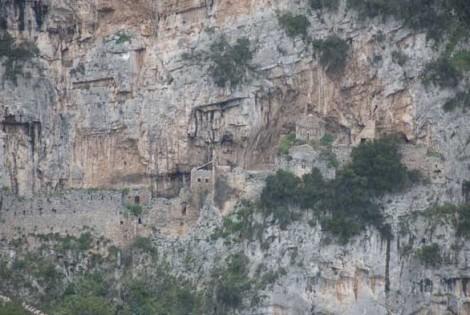
The Castle of Karytaina
Above the beautiful, traditional settlement of Karytaina, at an altitude of approximately 600 m., the castle of Karytaina stands majestically, overlooking the magical valley of the river Alfeios. The castle was built during te Frankish rule, in the 13th century, by the French sovereign Gottfried de Brulier, who used it for some time as his base.
The castle of Karytaina is also connected with the great protagonist of the Greek Revolution, Theodore Kolokotronis, who used it as a home and also as a base; its strategic spot atop the hill offered a very broad view of the area. In 1826 he also took up the necessary works to repair the damages the castle had suffered.
The castle of Karytaina is one of the most representative samples of 13th century French architecture. Access to it is relatively easy, up to a point; from there, though, the signs of abandonement become evident.
Built onto a large rock, on a hill with an altitude of 582 metres, stands the Castle of Karytaina, overlooking the village of the same name, spread out at its feet. The stone-built, triangular castle dates to the 13th century, and according to the Chronicle of Morea, was built by French lord, Geoffrey de Vrillier.
The Castle of Karytaina was one of the most noteworthy castles of the Frankish Occupation period, as well as the Turkish Occupation period. Its position was ideal because, in combination with its altitude, it was a central for communication between Arcadia, Messinia and the valley of the River Alpheios, which the locals used to call the Toledo of Greece owing to its exceptional beauty.
The strategic location of the castle drew the interest of conquerors, as was the case with most castles of the era. Among those coveting it were the Franks and the Venetians, who had a long presence in Peloponnesus. It played its most important role, however, during the Revolution of 1821, when it served as a refuge and base for many great chieftains, among them, Theodoros Kolokotronis. The “Old Man of Morea”, who was born in Libovisi of Karytaina, settled in the castle, reinforced it, built the Church of Panagia, and used the castle as his base against Ibrahim.
The castle today offers enchanting views across the entire valley of Megalopoli and the gorge of the River Lousios. Its interior is now in ruins, but the exterior walls are preserved in relatively good condition. After the first steep steps to reach it, to the left there stands a column, inside an enclosure, dedicated to a lieutenant who fell in the war, at the castle. Further down, there is the bust of Kolokotronis, while where the steps end, a stone path begins. The picture of abandonment in the interior of the castle has one positive aspect: the silence. If you listen carefully you can hear the memories of the past rising through every stone, every nook and every corner
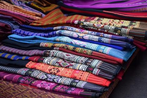
Karytaina – The Women’s Bazaar
Every August, hundreds of people visit the picturesque and traditional settlement of Karytaina on the occasion of the bazaar which is annually organized by the local women’s association. This bazaar usually lasts for 3 days and gives the women of Karytaina the opportunity to present various traditional products, like weavings, embroideries, as well as food and pastries, all handmade with love and care. The association also has a store in the centre of the village, which is open throughout the year and sells handmade products of exceptional quality.
Holy Monastery of Kalami
The majestic Monastery of Kalami is located approximately four kilometres from the village of Atsicholos and it is dedicated to the Dormition of the Theotokos. The Monastery comprises the old one and the new one, built within a small distance of each other in a magical landscape with an amazing view.
According to the evidence, the old Monastery, of which only some ruins remain, was probably built in the 15th century. A foundation plaque mentions that its main church was built and adorned with religious paintings in 1705; this date though is said to be referring to a renovation and not the initial building, which must have taken place much earlier. The murals that have been preserved are of great significance, painted by Petros Pediotis from Crete. Of the old Monastery a small chapel has also been preserved. The new Monastery was built in 1713, its religious paintings a work of Petros Pediotis and his brother, Michael.
Built in a lush green location, looking over the shores of the River Lousios, with a panoramic view across its gorge; the Monastery of Kalamiou honours by name the Dormition of the Madonna. It can be reached either through the village of Atsilochos or through ancient Gortyna. There are essentially two monasteries, the old and the new Monastery of Kalamiou, which lie within 200 metres of each other.
The old Monastery has the form of a castle-monastery, and is considered to be a building dating to the 15th century. It is in ruins today, with only very few remnants of the exterior wall surviving. Its church, which was built inside the rock, was painted in 1705 by Petros Pediotis, a painter from Crete; the expenses covered by Athanasios Koulopoulos from Karytaina. Some of these paintings have been preserved, as well as a small two-storey chapel. The old monastery is accessible today only through the new one, by a path that was paved in 1996 in the traditional style.
The new monastery was built in front of the old one, on a flatter surface, possibly because there was more prosperity to do this. Its church was built in 1713, again with the contribution of Athanasios Koulopoulos, and was again painted by Petros Pediotis, in collaboration with his brother Michael. During the Revolution, the new monastery fell victim to Ibrahim, because of the assistance it offered to the struggle for liberation. Some buildings in ruins remain, behind the church, but the monastery’s cells have today been renovated with great care.
Ancient Gortys – Archaeological site
Ancient Gortys is among the most important Arcadian cities of the ancient world. The exact dates of its founding, prime and decline are not known, since the archaeological evidence that has come to light is not enough to make an estimation. It is generally accepted, however, that the city was in its prime already in the 4th century B.C., and it was probably destroyed sometime around the 12th century.
The archaeological site is located outside the village of Atsilochos, in Mountainous Arcadia. Remnants that have come to light include fragments of the old fortification, ruins of houses and public buildings, a sanctuary of Asclepius and baths that were probably connected to this deity, with a curative purpose. The baths are among the most important ones to be discovered from the ancient world. They included a special heating system, which was considered by the researchers to be an Arcadian innovation.
The city also seems to be connected with the ancient city of the same name located in the valley of Mesara, near Heraklion, Crete. It is very possible that the Cretan Gortys was created by inhabitants of the Arcadian one.
According to myth, Ancient Gortys was founded by Gortys, the brother of Agamedes, son of Stymphalus and great grandson of King Arcas of the Lycaonides people. He gave his name to the city and also to River Lousios, which is called Gortynios at the stretch from Gortynia up to its confluence with river Alfeios. In antiquity, it was one of the most important cities of Arcadia and, according to what little is known, one of the oldest.
The city is situated next to River Lousios, at an altitude of 350 metres, a short distance outside the village of Atsilochos, in mountainous Arcadia. It was one of the stops on the route followed by Spartan athletes when travelling to compete in the Olympic Games, as the ancient road of Olympia – Megalopolis – Mycenae – Isthmus – Athens passed through here.
The city was guarded by two acropolises with strong fortifications, built close to one another, at an altitude of approximately 480 metres. It also had several temples and public buildings, burial grounds, a sanctuary of Asclepius, as well as two large baths, which formed an integral part of the worship of this deity. The baths operated from the 2nd century BC and had a special heating system, which archaeologists believe was an Arcadian invention. There was also a temple dedicated to Asclepius containing the god’s cult statue made by the famous sculptor Skopas of Paros. So renowned was this temple, according to Pausanias, that even Alexander the Great visited it in 335 BC, offered a sacrifice to the god and dedicated his spear and chest armour.
The exact date of the foundation of ancient Gortys is not known, owing principally to the lack of relevant written evidence and findings. There are, however, findings dating to the Late Helladic (1600-1100 BC) and up to the Geometric Period (11th – 8th century BC), thus verifying its age. The city’s most important period is placed during the Classical and Hellenistic Periods, with its peak specifically around the 4th century BC. Its decline, on the other hand, appears to have come after the foundation of Megali Polis, in 368 BC, when Gortys, together with neighbouring cities, was forced to unite with it, thus losing its autonomy. As a result, a large part of its population relocated to the new city. The city appears to have been finally destroyed around the 12th century AD, during the Byzantine Period, by the Goths.
During its peak years however, Gortys was a lively city, participating in the events of the wider region throughout its history.
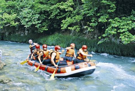
These two rivers, Alfeios and its tributary Lousios, flow along a continuously changing landscape in a breathtaking scenery of stunning natural beauty. The activities organized by various associations and clubs aim to bring visitors into close contact with the unique beauty of this region, also combining sports and recreation. Rafting is a very pleasant way to explore the region, regardless of your familiarity with the sport, since there are routes for every level; from beginners to highly experienced rafters.
The routes normally take approximately three to four hours and pass through gorges and natural tunnels, formed by trees, creating a stunning backdrop. The lush vegetation, the various and impressive species of birds, like falcons and herons, the stone arched bridges, the waterfalls that flow into the river, as well as the unique natural sculptures the water has carved into the rocks, all contribute to the amazing experience you will have in Arcadia. It is certainly something you don’t want to miss.
Ano Lousios also offers one of the most difficult, yet extremely interesting rafting routes in Greece. It’s suitable only for very experienced rafters or for those who are trained to become rafting guides. When the river is swollen, rafters need to be particularly cautious, since the waters become impetuous.
Erymanthos is another tributary of Alfeios, as well as a natural boundary between the prefectures of Ilia and Arcadia, and is yet another river suitable for relatively difficult descents. Previous experience is recommended, as well as a pretty good physical stamina. The descent lasts for approximately five to seven hours and there are two recommended starting points: the first from Tripotama and to Vidiaki -after 15 kilometers- and the second from Vidiaki to Elaia -after 8 kilometers.
In addition to rafting, the rivers are also ideal for various other activities. Adventurous types can indulge in hydrospeed and enjoy a unique experience with just a pair of fins and a board. You can also go for monoraft, where you cross the river with a one-seater raft, which is something equally exciting. You can also go for rappel and cross the gorges with special ropes, which will help you descend to the vertical waterfalls. The less adventurous will enjoy unique routes, exploring the shores of the rivers, as well as the surrounding areas with the lush vegetation and scenic settlements. Whatever you decide to do, you can obtain information, guidance and the necessary equipment from any relevant association, club or company in the region.
The routes are suitable for every level of experience. You can address one of the numerous associations or clubs that will recommend the right one for you, based on your physical stamina and experience. They will also provide you with the proper equipment, as well as guidance for your safe descent.
River Lousios and its Gorge
Lousios is a Peloponnesian river and a tributary of Alfeios. It is a relatively small river, approximately 25 kilometres long. However the landscape that surrounds it on its both banks is magical. The name of the river has ancient origins. It is said that it was given this name because the newborn Zeus was bathed (Louzo=bathing) in its waters by the nymphs Theisoa, Neda and Agno.
Near Karytaina, River Lousios crosses a gorge of substantial environmental importance, about 26 kilometres from its mouth. The natural beauty of this gorge fully justifies its characterization as a protected zone by the Ministry of Culture in 1997. Its flora is rich, and its fauna includes many species of reptiles, birds and even bats. There are numerous monasteries, churches and hermitages around the river, evidence of the religious life that developed there in the past.
The gorge is ideal for a plethora of activities, like rafting and kayaking. It is a particularly impetuous river and is certainly not recommended for beginners. However, the crossing of the gorge is something suitable for everyone and a truly unique experience.
Lousios originates in the location of the ancient town of Theisoa, near the village of Karkalou, as well as further to the north, near Kaloneri, in the location of the church of Agia Paraskevi. These two streams meet up in Karkalou, where Lousios continues its course, to end up after 25 kilometres in Alfeios and flow into somewhere near Karytaina. In its relatively short course, Lousios gives life to the entire surrounding area and dazzles with its natural beauty that includes flora, fauna, unique formations, waterfalls and an incredible gorge.
The river was already known in ancient times. Pausanias thought it was the coldest river in the world and he also mentioned a myth associated with its name. According to this myth, the nymphs Neda, Agno and Theisoa took the newborn Zeus and bathed him, without his father Cronus knowing about it, in the springs of the river, which were named the Springs of the Immortals. He also says that from ancient Gortyna up to its estuary, the river’s name is Gortynios, something accurate until today.
Lousios is an impetuous river and it contributed to the development of the wider area. The residents realized its power and took advantage of it by building tanneries, watermills, flour mills, distilleries and particularly gunpowder mills. All this activity made the area renowned for its specialization in hydromovement. All this and much more can be seen at the unique Museum of Water Power in Dimitsana.
The gorge of River Lousios is one of the most impressive attractions in the prefecture of Arcadia. It is 15 kilometres long and around 2 kilometres wide. On its western side it goes through the National Trail 32, which is part of the European trail E4 GR that starts from Vytina, passing through the villages of Zygovisti, Dimitsana and Paliohori, the Monasteries of Philosophou and St. John the Baptist, then through Karytaina to end up in Gytheio. This entire area is truly amazing. The flora is rich and includes laurels, maples, willows, yews, myrtles, plane trees, elms, poplars, firs, olive trees and many more. The fauna is equally impressive, including various species of reptiles, birds, fish and mammals that live here throughout the year.
Religious and ascetic life developed on both sides of the gorge, especially during the Turkish occupation; something obvious from the existence of numerous monasteries, churches and hermitages, like the monasteries of Aimyaloi, Kalamiou, Philosophou, St. John the Baptist and the church of Agios Andreas of Gortyna. The wild beauty of the area combined with the serenity of nature were ideal for anyone who wanted to feel closer to God.
The gorge of River Lousios is perfect for many activities, like canyoning (crossing the river by various means), canoe-kayak, rafting, hiking and trekking. The hiking trails are numerous, each one with something different to offer. In 1997 the gorge was declared as an area of particular archaeological and environmental importance and was placed under the auspices of the Ministry of Culture.
We highly recommend that you try rafting by crossing the river Lousios by boat …
Starting from our villa, driving for about 75 minutes and after about 45 km, passing the picturesque and amphitheatric village of Kastanochori, the villages of Kato Karyes, Thoknia, Kyparissia, Mavria, Karvounari and passing by Karytaina you will reach the capital of the local Municipality of Gortynia, Dimitsana. There you will come across a sign that will take you to the Water Power Museum that is open to you. We advise you to call before you start to ask about the opening hours of the museum.
Phones
Water Power Museum of Dimitsana: +30 2795031630
We recommend that during this trip you can make a stop at the Panagia Karvounareiki for pilgrimage and a stop at the “Papakia” multifunctional complex that has a remarkable private zoo and can give you moments of relaxation at all ages. It features a playground, café and food.
Immediately afterwards, we also recommend that during this trip you can take a stop in the picturesque village of Elliniko, which is a short distance from Karytaina and make your walk in the paved alleys. Here you will find choices for coffee and food.
A few minutes after Elliniko village you can visit the picturesque village of Psari, following the signs and leave as last stop before Dimitsana, the village of Stemnitsa. Here it is worth visiting the Silver-Gold Jewelery School that is open to you. We advise you to call before you start to ask about the school opening hours.
Walking through the paved alleys you will find shops selling handmade jewelery and traditional sweets. Here you will find choices for coffee and food.
Phones
Silver-Gold Jewelery School in Stemnitsa: +30 2795081514
Between the distance from Stemnitsa to Dimitsana, it is worth visiting the monasteries of Philosophou and Prodromou, located just a few minutes outside the village. Route and view will also compensate you.
Stemnitsa
Stemnitsa is one of the most beautiful and historical villages in the prefecture of Arcadia, and is located between Dimitsana and Karytaina. The village is built onto the slopes of Mount Mainalo, near River Lousios, ancient Gortyna and numerous renowned monasteries amidst cherry, walnut and plane trees. During the Turkish domination, Stemnitsa evolved into a major hub for metallurgy and its -mostly itinerant- craftsmen (goldsmiths, silversmiths, blacksmiths, bell and cowbell manufacturers, coppersmiths, etc.) created exceptional works of art, even beyond the borders of Arcadia. In the vicinity of Stemnitsa there are at least 20 Late Byzantine churches of truly stunning architecture and style, as well as the monasteries of Philosophou, St. John the Baptist, Aimyalon and Kalamiou Atsiholou; all major hubs of asceticism and rich Christian Orthodox tradition. The stone tower houses, the rivers and springs, the delicious local pastries, the unique natural beauty, as well as the modern tourism infrastructure make Stemnitsa the ideal destination for winter or summer holidays.
Stemnitsa is one of the most beautiful and historic villages in Arcadia, on the road between Dimitsana and Karytaina, on the slopes of Mainalo. It is surrounded by cherry, walnut and plane trees and has been built near Lousios river, ancient Gortyna and well-known, opulent monasteries.
Stemnitsa, which used to be called Ypsous, was probably founded in the 12th century and during Byzantine times it was famous for the production of bells. During the Ottoman rule it developed into an important metal-working centre and its –mainly itinerant– craftsmen (goldsmiths, silversmiths, blacksmiths, bell makers, tinkers etc.) created works of excellent art even beyond the borders of Arcadia. This long tradition is continued today by the Silver-Gold-Smithery School.
In the area around Stemnitsa there are at least 20 post-Byzantine churches created with excellent craft: Zoodochos Pighi (15th century), Treis Ierarches (17th century), Aghios Georgios (1810) and Panaghia Bafero (17th century), to mention a few. Not far if you are travelling by car, or even after very nice walking excursions, you will find the well-known Monasteries of Philosofou, Timios Prodromos, Emialon and Kalamiou of Atsicholos, all excellent centres of ascetism and rich Orthodox tradition.
Heading south from Stemnitsa, just after the village of Elliniko, in an enchanting location, you will come across ancient Gortyna. The archaeological site has easy access and at the end of hiking paths lie findings that range from ancient to Byzantine times: sanctuaries of Asclepius, temples, baths, public buildings, fortification walls, houses and also stone bridges and Byzantine churches, they all narrate the long history of this city, built by the great-grandson of the mythical founder, Arcas.
A walk around the settlement reveals to the visitor imposing stone tower houses, such as the three-storey residence of the Roilos and Giannakos Kolopanas family, as well as the residences of Bournazos and Hatzis, where the Folklore Museum is also housed. Here you will find representations of traditional professions’ workshops, such as that of the silversmith, the bell-maker, the tinker, the candle-maker and others; the Museum also houses an interesting collection of post-Byzantine icons, ceramic and embroidery works, wood carvings, textiles and costumes, among other things.
The many arched stone fountains, the impressive view from the mound of Kastro, the amazing local sweets (diples, bourekia etc.), the excellent tourist facilities with accommodation and eateries, the stone tower houses, the plentiful waters, everything situated in an area of great natural beauty, between the fir forest and the great sites of Lousios gorge, make Stemnitsa an ideal place to spend your summer or winter holidays.
The 1st Peloponnesian Senate – Stemnitsa
The 1st Peloponnesian Senate, which was the first Government of the Rebellious Greeks, was formed in the Monastery of Kaltezes on May 26th, 1821, in the presence of 40 dignitaries, who composed the statute “Patris” (Country), the first official document of the liberated Greek state. Stemnitsa was the seat of the Peloponnesian Senate and the Monastery of the Blessed Virgin Mary of Chrysopigi was set as the temporary headquarters of the state’s government.
The Municipality of Gortynia annually organizes every June various celebratory events to commemorate and honor this important event. The celebrations begin with the Divine Liturgy at the Monastery of Zoodochos Pigi, followed by a Doxology and a celebratory speech. The day ends with traditional dances in the village’s main square.
The Monastery
of the Blessed Virgin Mary of Philosophou
The Philosofou Monastery is located in the Prefecture of Arcadia, south of Dimitsana, at the gorge of the river Lousios. It is also known as Emiali Monastery and comprises two parts, an older and a newer one, at a small distance within each other. The older part was built in 963 A.D. by Ioannis Lambardopoulos, the so called “philosofos”, secretary of Nikiforos Fokas, from whom the Monastery took its name. The new Philosophou Monastery was built in the 17th century and opened soon after.
The old Philosofou Monastery, which is today deserted, is the oldest monastery in Arcadia and one of the most historic ones in Greece. During the Turkish rule, the famous today Secret School operated there, which developed into a religious school that later operated in the New Monastery. From the ranks of this school sprang important personas that played a decisive role in the liberation of the Greek nation. Until 1691 the Monastery continued to flourish as a spiritual centre. Between the years 1834-1836, however, its disbanding was decided, so it gradually fell into decline. Fairly recently it was declared a protected monument, and that’s when its maintenance and restoration works began.
The Monastery of the Blessed Virgin Mary of Philosophou -the old and the new- is located to the south of the historic village of Dimitsana, in the area of Monopori, within the gorge of River Lucius and it is dedicated to the Assumption of Theotokos.
The old monastery was established in 963 AD by Ioannis Lambardopoulos, who was born in Dimitsana and served as secretary to the emperor Nikoforos Fokas. Ioannis Lambardopoulos, owing to his exceptional education, bore the name “Philosophos” (Philosopher), mimicking other Byzantine rulers; hence the name of the monastery. It is one of the oldest monasteries in Greece, is stavropegic and is built inside a natural cave. According to tradition, during the dark years of the Turkish domination, it housed a Secret School which was later transferred to the new monastery and became a renowned seminary. Many prominent figures of the Greek nation attended this school, as well as teachers, priests, monks and leading personalities of the ecclesiastical life, such as the Patriarch Grigorios V and the Bishop Germanos, known as Palaion Patron Germanos. Today, the old monastery is deserted. Only one small chapel in the Byzantine style from the 10th century is now preserved, with very few, but notable, frescoes, as well as remnants of cells and other buildings.
The new monastery was built near the remnants of the old one, around the middle of the 17th century. Initially they constructed its main church and few cells and they operated it alongside the old one. The church was painted in 1693 at the expense of Mavraidi Pasha Farmakis, who was born in Stemnitsa, became a Muslim and then converted back to Christianity. Farmakis is depicted on the west side of the church, having characteristic eastern features. Within the framework of the School there was a notable library that among others included important manuscripts from the 12th century, which are currently kept in the National Library of Athens.
The Monastery of the Blessed Virgin Mary of Philosophou is called “the Princess of the Gorge”, being an impressive structure with rich history and a tremendous contribution to the enlightenment of the Greek nation. Its decadence begun after the liberation of the Greeks, up until 1834, when it was finally closed down by decision of the Bavarian Regency. This is how its glorious course through the centuries came to an end. However, it still stands proud in the stunning landscape that surrounds it, haunted by memories of the past.
Emiali Monastery
The historic monastery of Panaghia of Emiali is situated just outside Dimitsana, built inside the rock. It was founded in 1608, according to the owners’ inscription, by Grigorios Kontogiannis, a monk and priest, and his sister, nun Efpraxia Paisia Kontogianni, from Emiali, a village in the Prefecture of Messenia, whence the monastery took its name.
The Emiali Monastery played a very important role during the Turkish rule and also after the Greek Revolution, by offering significant services to the fighting Greeks, both in the form of financial support and as a spiritual centre. The Monastery knew glorious days, but around the 19th century it slowly started to decline, as a result of various internal conflicts. At that time it merged with the Monastery of Timios Prodromos, of which it since functions as a glebe. The Monastery has at times operated both as a men’s monastery and as a convent, in its present phase, though, it hosts monks from the Monastery of Timios Prodromos.
The Monastery of the Blessed Virgin Mary of Aimyaloi is located approximately three kilometres from the scenic and historical settlement of Dimitsana, in an area with lush vegetation, and was initially built inside a rock formation. The Monastery was established in 1608, according to its founding inscription, by the monk and spiritual father Grigorios Kontogiannis and his sister, nun Efpraxia Kontogianni (or Païsia), who came from the village of Aimyaloi in the prefecture of Messinia; hence the name of the convent. Sometimes it appears as the Monastery of Omaloi or Omyaloi. Some people question the Greek origin of the name “Aimyaloi”. However, in Mani “aimyalos” means edible snail.
The entrance to the Monastery is a gate, which leads to a verdant courtyard. The first cells were carved into the rock and visitors are able to see their remnants. The shape of the monastery has changed significantly, since new buildings were added and many expansions have taken place. The main church of the monastery was initially small, but later on was also expanded. It is a small one-aisle basilica, built inside a natural cave. The frescoes were painted during the monastery’s foundation year, with remarkable examples of Byzantine art of the Cretan School, creations of brothers Dimitrios and Georgios Moschos from the city of Nafplion, who were famous painters of the time.
The Monastery of Aimyaloi offered substantial support during the dark years of the Turkish occupation, as well as during the Greek War of Independence. This support was both moral and material. It was a cradle of culture and of the Orthodox church, while it also financially supported the Greek Revolution; when in 1822 the Peloponnesian Senate requested help from all the monasteries of the area, the Monastery of Aimyaloi contributed 750 piastres. Several notable heirlooms are kept in the monastery, one of which is its founding code, with important information about its establishment. The code is currently on display in the Library of Dimitsana.
The Monastery of Aimyaloi had a long, thriving course, which was stemmed however towards the end of the 19th century, when the first signs of decadence started to occur, something that led to its unification with the Monastery of St. John the Baptist. Today it remains as a metochion of the latter. During its course, it operated as a male monastery, but also as a nunnery. However, since 1995 it has been a male convent, and it is celebrated on the 8th of September, on the Nativity of the Blessed Virgin Mary.
The Monastery of Prodromos
The Monastery of Aghios Ioannis Prodromos is located at the Lousios gorge, very near the historic villages of Stemnitsa and Dimitsana. Its foundation dates with some uncertainty to the mid-16th century, it is known, however, that centuries earlier there were many hermitages in the area, which were merged together during the Turkish rule, constituting the Monastery of Prodromos.
During the Greek Revolution of 1821 the Monastery operated as a refuge and hospital for the warriors. After a brief dissolution in 1834 it was reconstituted in 1838 and prospered greatly. It owns several old documents, patriarchal sigils and a rich collection of books. The Monastery complex includes an old church of Aghios Athanasios, which today functions as a hagiography workshop and a workshop for the sewing of holy garments, the chapels of Metamorfosi and Ipapanti, an olive mill and watermills.
A great amount of people visit the Monastery every year; apart from revering this remarkable monument of the Orthodox faith, they also come to admire the imposing landscape that surrounds it.
Dimitsana
Dimitsana, imposing and amphitheatrically built at the slopes of Mainalo, about 59 kilometers northwest of Tripolis and surrounded by verdant hillsides, dazzles visitors with its stone houses and cobbled narrow streets, the scenic churches and the Open-Air Water Power Museum, but also with its bridges, springs, mills and the natural beauty of River Lousios that flows nearby. Dimitsana flourished from the 17th until the beginning of the 20th century. The main professions of the residents were trade and metallurgy. Its economic prosperity led to its intellectual prosperity with the establishment of the famous Greek School. The town -also known as “the Arsenal of the 1821 Revolution”- became famous also for its water-power facilities that were supplying with energy the local flour mills, the fulling mills, the tanneries and most of all the gunpowder mills. Today, Dimitsana with its rich history, the impressive monuments, archaeological and pre-industrial sites, the natural beauty, the scenic churches, the imposing monasteries and the renowned nearby villages is one of the most interesting areas of Arcadia.
Dimitsana, surrounded by verdant hillsides, imposing, built amphitheatrically on the slopes of Mainalo, is situated 59 km. northwest of Tripoli. It is very impressive with its stone houses and very charming with its paved alleys, its churches and the Open Air Water-Power Museum, as well as the bridges, the fountains, the mills and all the beauties of Lousios river, which flows near the settlement.
Dimitsana is located approximately 1 km above Lousios; on the one hand, the river is surrounded by wild, virginal beauty with rich flora and fauna and old industrial plans that utilized the power of water, and on the other hand, at the Lousios gorge there are monasteries and hermitages, which developed mainly in post-Byzantine times. All these beauties are accessible through old and new paths that facilitate the hikers.
The traditional, stone-built settlement of Dimitsana is very charming with its excellent facilities –accomodation, restaurants, taverns–, with its traditional products (sweets, meat, honey, pasta), with its buildings that testify to its rich past, financially and culturally, and also the museums and the possibilities it offers for hiking excursions in the nearby areas.
A tour around Dimitsana allows the visitor to admire from up close elegant churches (Aghia Kyriaki, Aghios Georgios, Aghios Charalambos, Metamorfosi tou Sotiros and others) and also the Ecclesiastical Museum, housed in the renovated home of the Patriarch Gregorios V. The old mansions, among which the single five-storey house of Xenios with its murals, which today has been converted into a guesthouse, the marble campanile tower, the stone bridges, the fountains, the amazing excursions to the “verdant” monasteries (Old and New Philosophou Monasteries, Monastery of Timios Prodromos, Emiali Monastery), Lousios gorge and the nearby pretty villages Paleochori, Marko and Zatouna, each with its unique beauties and worth-seeing corners, they all comprise a unique experience in Arcadia.
Dimitsana, built on the site of the ancient city of Tefthis (near the church of the Taxiarches and among the houses we can still see fragments of the city’s ancient wall), gradually rose to great prosperity from the 12th century onwards, but mainly from the 17th to the beginning of the 20th century. Its merchants travelled for business all the way to Odessa, Constantinople and Smyrna. The inhabitants became mainly merchants and metalworkers (goldsmiths, silversmiths, tinkers) and the financial prosperity also brought about the cultural prosperity of the town, with the famous Greek School, founded in 1764 by the locals Georgios Gounas and Agapios Leonardos; the School mainly developed after 1816 and many important personas of modern Greek history (the Patriarch Gregorios V, Paleon Patron Germanos, Papaflessas and others) studied there. The School’s rich library, supplemented with many more additions today, is housed in the old building of the Elementary School and includes handwritten codices, old editions, a historical archive, a folklore collection and archaeological findings.
Dimitsana became famous for its water-power plants, which set to motion flour mills, water mills, tanneries, but mainly gunpowder mills, whence the town took the name “the 1821 Revolution’s weaponry”. Today, just outside the settlement, at the location of Ai Yannis, we can visit the innovative Open Air Water-Power Museum, which opened in 1997 and has since been operating by the Piraeus Bank Group Cultural Foundation; the old facilities have been restored and the amazing result contributes to the preservation of the knowledge regarding traditional water-power technology in the area, which flourished in the 16th century.
Dimitsana today, with its rich past, its monuments and archaeological and early-industrial sights, its natural beauties, pretty churches, impressive, famous monasteries and well-known nearby villages, is one of Arcadia’s most interesting areas.
The Open Air Water-Power Museum – Dimitsana
The Open Air Water-Power Museum opened in 1997 near Dimitsana, in Kefalari of Ai-Yannis. The Museum aims to promote the significance of water power in local society in the pre-industrial era.
It is a thematic museum; for its creation, the buildings of the industrial complex that used to operate in the area were re-erected and its mechanisms were maintained, with the exclusive use of water power. As a result, the visitor today can see the gunpowder mill, the tannery, the water mill, the flour mill, the distillery, as well as the residences of the miller and the tanner. Moreover, most workshops are in functioning condition, and the visitor can follow from up close the production process.
The museum is close to other natural beauties in the area, providing the opportunity for a visit to Lousios gorge, to the bridge of Monopori, to the Philosofou and Prodromos Monasteries, and also to ancient Gortys.
The Open-Air Water Power Museum in Dimitsana is an innovative museum established in 1997 in the location of Kefalari Ai Giannis, just off the town of Dimitsana. It is housed in the abandoned pre-industrial facilities, which were renovated with funding from the Cultural Institute of Technology in cooperation with the 2nd and 3rd EU Framework Programme and the Peloponnese District. These facilities operated for five consecutive centuries (16th – 20th century), serving the needs of the wider region. The driving force of the complex was the water from the spring of Kefalari Ai Giannis.
The goal of the open-air museum was to revive the old practices that used water as energy for the production of various goods, as well as to showcase the importance of the element of water in various productive activities of the pre-industrial era. The museum is located within an area of approximately 4,000 square metres, with lush vegetation, where they have renovated the premises of the old workshops, each housing a permanent display related to its prior operation.
The first building houses a flour mill and a fulling mill. Up until the middle of the last century, there were numerous fulling mills in Dimitsana, and the respective profession was very popular. Here they were washing the weavings and this demanded a specialized knowledge. In the flour mill, the visitor has the chance to watch live demonstrations of the seed being ground by the millstones, before falling into a special container. The miller’s residence is housed in that same building, where he would normally live with his entire family. Further down we can see the tannery, which is divided into zones, depending on the type of work conducted there. The residence of the tanner is also housed here. The premises also include a gunpowder mill, which reminds us of the special role of Dimitsana as the main supplier of gunpowder during the Greek Revolution. Visitors will also have the opportunity to see a fully functional raki cauldron, where they used to make tsipouro.
All the exhibition halls provide detailed information about each workshop, and in certain cases there is also audiovisual informational material available.
Library of Dimitsana
The Library of Dimitsana is an important stop for the visitor of this historic area. It was founded in 1764 by two monks, Gerassimos Gounas and Agapios Leonardos, from the School of Smyrna. Initially it functioned as a theological school, and many important Greek prelates studied here during the Turkish rule.
The largest part of the Library’s rich material was sacrificed on the altar of the Greek Revolution of 1821, when the books’ pages were used for the making of cartridges. Of its old volumes, around 600 were preserved. Through the years the library’s material was enriched with various donations, so that today it has approximately 35,000 volumes. Apart from books, the Library is also home to rare documents, codices and manuscripts, as well as various mementoes from the Revolution.
The scenic and historical village of Dimitsana is one of the custodians of the historical and folkloric traditions of the Greek people. Apart from the beauty of the landscapes, the visitor can also admire important heirlooms and souvenirs from various moments of the Greek past, which are safeguarded in its museums and in its historical library.
The Library of Dimitsana, today also known by its official name, the Public Library and Museum of the Greek School of Dimitsana – Local Historical Archive of Gortynia, is located on Agias Kyriakis Square, where the old schools used to be, taking the place of the Dimitsana School in 1845. It is a beautiful location, “looking out” over the impressive gorge of the River Lousios with its historical monasteries, the Filosofou, Prodromou and Aimyalon Monasteries.
The library was founded in 1764 by two monks of the School of Smyrna, Gerasimos Gounas and Agapios Leonardos. During the years of the Greek Revolution of 1821, it played an important role as a teaching and theological school, where important people of the church studied, such as the Ecumenical Patriarch Gregorios the 5th, and Palaion Patron Germanos.
The Library contains the office, the study room, a large circular room, a small room with a collection of archaeological findings, as well as basements where its invaluable treasures are kept. These treasures include a rich collection of manuscripts and codes, which comprise the historical archive of Gortynia, and manuscripts with a variety of content, not only theological. They also include various study books, patriarchal documents and Turkish firmans. Beyond these, the library also holds various heirlooms from the Revolution: here the visitor can see the saddle of the horse of Papaflessas, the bones of Palaion Patron Germanos, kept in a bronze reliquary, which were moved here from Patras in 1930; various portraits of important figures of the revolution, as well as a small collection of various folk art objects.
Of the rich collection of the library’s old books, unfortunately many were destroyed when, during the Revolution, their pages were used to make cartridges. Only 600 were saved from the original books. Gradually its content was enriched once more through donations, and today it counts more than 35,000 books, while the famous collection of manuscripts has reached 200. In 1977 the Library of Dimitsana was honoured by the Academy of Athens with a gold medal and a diploma, in official recognition of its important contribution.
Ecclesiastical Museum of Dimitsana
Near the square of the historical village of Dimitsana, the visitor will find the Ecclesiastical Museum of Dimitsana, which is housed in the renovated home of Patriarch Gregorios V. The Museum was an idea of the Most Reverend Archbishop of Gortys and Megalopolis, Theophilus.
It is a two-storey building in the traditional architectural style, where various ecclesiastical artifacts are exhibited, such as icons, sacred vestments, holy utensils, crucifixes and holy gospels. The building’s basement has been converted into a chapel, in honour of Saint Gregorios V. Here the exquisite icon of Saint George is also kept, a work in the Mount Athos style, of 1808.
Upon entering the Museum, the visitor comes across a sign that bears the following inscription: In this house was born Patriarch Gregorios V, hanged on April 10, 1821 in Constantinople. A visit to the Museum pays tribute not only to the Greek religious tradition, but also to the tumultuous history of the Greek people in their struggle for freedom, steeped with torment and blood.
Close to the square of the historical village of Dimitsana stands the Ecclesiastical Museum of Dimitsana, housed in the renovated residence of Patriarch Gregory V. This museum was created in 1992 with the encouragement of the Bishop of Gortyna and Megalopoli, Theofilos, and with the help of brothers Panagiotis and Dimitrios Evaggelopoulos, from the village of Vlahorrafti.
It is a two-storey house with a basement, preserving several traditional architectural elements. Over its two floors, connected by an interior stone staircase, the exhibits are displayed in special cases, while the basement has been turned into a small church in honour of Saint Gregory V. The museum’s exhibits come from Dimitsana and the broader region of Gortynia, from the numerous churches and the multitude of monasteries from the Metropolis of Gortyna and Megalopoli. These include sacred vessels of the Divine Service, relief crucifixes, old books, incense boats, the Testaments, gold embroidered canonicals, a painted vestry, while there is also a remarkable collection of various types of icons. Especially important is that of Saint Georgios, which according to the inscription on it, was dedicated by Gregory V to Saint Georgios of Dimitsana, and it is a work made in Mount Athos in 1808. The museum also has three despotic icons from the Church of Taxiarches of Dimitsana, which belong to the 17th century Cretan School, an icon of John the Precursor as well as an altar door depicting the scene of the Annunciation.
Starting from our villa, driving for 75 minutes and after about 80 km, passing the picturesque villages of Lykeo, Lykosoura and the villages of Apiditsa, Choremis, before the village of Gefyra you will enter the TRIPOLIS-KALAMATAS highway towards Tripoli. Passing Tripoli and before Nestani toll, the signs will take you to the Kapsia Cave that is open to you. We advise you to call before you start to ask about the opening hours of the cave.
Phones
Kapsia Cave : +30 6942411384, Fax: +30 2710243575
E-mail: [email protected]
After your visit to the cave, driving for 25 minutes and after about 17 km, we recommend you to visit the ski resort of Menalon, which runs in winter, to enjoy the snowy scenery and ski. We advise you to call before you start to ask about the opening hours of the ski resort.
Phones
Ski Center Menalon : +306985063909
If you do not want to do winter sports, then after your visit to the cave, driving for 10 minutes and after about 10 km you will reach the picturesque village of Levidi. It is worth a stop and walk to its paved alleys. Here you will find choices for coffee and food.
Leaving Levidi, driving for 19 minutes, after about 19 km, you will reach the beautiful and picturesque village of Vytina. It is worth a stop here. Walking along the paved alleys you will find shops selling handmade items for every use and local traditional sweets and food. Here you will also find many options for coffee and food.
After Vitina, we suggest you drive for 23 minutes and even after 23 km you will reach the beautiful and amphitheatric village of Lagadia. It is worth a stop and walk to its paved alleys. Here you will also find choices for coffee and food.
The Kapsia Cave in Arcadia
One of the 10 most notable caves throughout Greece is located approximately 15 kilometres north of Tripolis, near the village of Kapsia. It’s the beautiful Kapsia Cave which, as one can imagine, is of particular interest.
The cave was explored for the first time in 1887 by the French archaeologist Gustave Fougères, who was conducting research and excavations in the area of ancient Mantineia. The systematic research of the cave did not start until 5 years later, followed by numerous other explorations that revealed its wealth and beauty. As confirmed, this cave was a human refuge, since human bones and evidence of inhabitation have been found here. Particularly impressive is the so-called “Chamber of the Splendid”, where visitors can witness a natural environment of unparalleled beauty, created by the rare colours of the rock formations.
The village of Kapsia belongs to the Municipality of Mantineia and is built at the foot of Mount Mainalo, at an altitude of 700 metres. The Kapsia Cave, which is one of the most important attractions of the region, as well as among the ten most notable caves in Greece, is located approximately one and a half kilometres north of the settlement.
The cave became visitable for the first time in 2010 -relatively recently- one year after the completion of the necessary works. However, it was already well known, even since 1887, when the French archaeologist Gustave Fougères visited it for the first time as part of his excavation expedition in the wider area of ancient Mantineia. The first exploration of the cave took place in 1892 by a speleological group, consisting of Greek and French experts. In 1974 there was another Greek-French expedition, which revealed several different sections of the cave. Its recent inauguration took place in the presence of many public figures, in recognition of its scientific and touristic importance.
The Kapsia Cave is part of a system of active and inactive sinkholes in the Mantineia Plateau – there are three sinkholes in front of the entrance to the cave, surrounded by a semicircular stone dam. Its interior is particularly impressive, with incredible stalactite and stalagmite formations, which combined with the rare hues of the rocks is creating a unique scenery that seems out of this world. Particularly impressive is the so-called “Chamber of the Splendid”, where you will witness the most incredible colour shades of any other Greek cave. Many human bones and oil lamps have been discovered inside the cave, evidence of inhabitation in ancient years; most probably during the Neolithic and the Hellenistic eras. According to some researchers, the bones belong to people who drowned in the cave during a flood.
To date, around 6,500 square metres of this cave have been explored, and its visitable area has been properly organized, with the addition of lighting and trail marking.
Levidi
Levidi is built at the foot of Mount Mainalo, a few kilometres north of Tripolis, on the way to Vytina, and it is a historic, well organized town with a rich folklore tradition, as well as the birthplace of the prominent early 20th century politician, Alexandros Papanastatiou. The traditional guest houses, as well as the restaurants, the taverns and cafes, where visitors can enjoy delicious products, the famous wines of the valley, the lovely main square, the church of Agioi Taxiarches atop a hill with panoramic views to the settlement, the Arcadian Museum of Art and History, the Kapsa Cave, with its impressive stalactites and stalagmites, ancient Orchomenos and Mantineia, the Monastery of Kandila and finally the nearby Mainalo ski centre all make Levidi an extremely attractive destination throughout the year.
Levidi, at the edge of mountain Mainalo, at an altitude of 850 m., only a few kilometres north of Tripoli, on the road to Vytina, is an historic, neat town, with rich folklore tradition and a population of approximately 700 permanent residents. It is the hometown of the great politician of the beginning of the 20th century, Alexandros Papanastasiou, who rose as the leader of the liberal democratic party, served as prime minister and was the founder of the Republic regime (1924). His bust stands proudly at the settlement’s square, along with the statue of Anagnostis Striftopoulos, a hero of the 1821 Greek Revolution.
The traditional guesthouses, the places where the visitor can taste the delicious local products and the famous wines of the valley, the beautiful main square, the church of Aghii Taxiarches, the small Byzantine church of the Panaghia with murals, built with ancient materials from the sanctuary of Artemis Hymnia, as well as the two clocks, the old and the new (the old one still shows the time when the Germans blew it up) at the top of the hill with the panoramic view of the settlement, are some of the sights worth seeing that the visitor will discover.
The Arcadian Museum of Art & History, located at the “Dryades” alternative tourism complex, houses an interesting collection of art works by western-European and Greek artists from the 16th to the 20th century, while the Alexandros Papanastasiou Museum holds mementoes from the personal and public life of this great politician.
The noteworthy locations in the nearby area, such as the ancient Arcadic city of Orchomenos, with ruins that traverse antiquity until its end, and the touching remains of an ancient theatre, the ancient city of Mantineia, the Kandila Monastery, perched on the rock, the heroic village of Paleopyrgos, with the remarkable carved wooden chancel screen of the 15th century church of Kimisi tis Theotokou, the Kapsia cave, with stalagmites and stalactites, as well as the Mainalo Ski Resort, they all constitute Levidi an extremely attractive area for a relaxing stay year-round.
Vytina lies in a valley at the foot of Mount Mainalo, at an altitude of 1.033 meters. It has an excellent climate and it’s a very popular winter holiday destination. In the past, Vytina was the place people with lung and thoracic diseases were choosing for a full recovery. After World War II most of its population migrated, but today it’s a bustling, scenic village with an excellent tourism infrastructure and exceptional local products (dairy, pasta, honey, wooden carvings), constituting an ideal holiday destination and a great starting point for touring the beautiful mountainous Arcadia. Vytina is very close to the Ski Center of Mainalo, it has a lovely picturesque main square, the impressive church of Agios Tryfonas, a renowned Forestry School and an interesting Folk Art Museum. There are many notable nearby destinations that surely worth a visit, like Methydrio, Pyrgaki, Elati, the historic Alonistaina, ancient Orchomenos and the Monastery of Agioi Theodoroi.
Vytina is built at an altitude of 1,033 m., in a valley at the foot of Mainalo; it has a healthy climate and a great reputation as the ideal winter destination. It is located near the Ski Centre of Mainalo and its tallest summit, Ostrakina, (at 1,980 m.), with eight pistes, one of the best equipped and most modern ski centres in Greece, with excellent facilities for beginners, advanced and also for visitors.
A long time ago, until 1940, Vytina was an ideal place for the recuperation of patients suffering from lung and chest diseases, it had two sanatoria and it was also known for its Forestry School. After World War II most of Vytina’s population moved away, but today, with its excellent tourist facilities and amazing local products (dairy, pasta, honey, wood carved items), it is the ideal place to relax or to plan your excursions to the beautiful landscapes of mountainous Arcadia.
Vytina has a very beautiful square, with the impressive church of Aghios Tryfonas –with its blackish marble– and a rich Folklore Museum. At the square one can see the busts of historian Constantine Paparigopoulos, who hailed from Vytina, as well as that of an important jurisconsult, Vassilios Oikonomides. The interesting Folklore Museum is housed in a stone building and includes tools, holy utensils, household items, clay artifacts, costumes, furniture, a loom, old photographs, etc.
Vytina is always a preferred destination in order to get away for a few days and not only. With excellent accommodation facilities, exquisite local products that are always in demand (pasta, herbs, fir honey, dairy products, decorative items and useful wood carved items), and also the comestibles offered in nice premises, it is unforgettable and always desirable.
The surrounding villages: Methydrio, near the homonymous ancient city with its ruins, Pyrgaki, with the abandoned houses and the amazing fir forest surrounding it, the stone-built Elati, with the woodcarving workshop, the historic Alonistena, a traditional, preserved settlement associated with Theodore Kolokotronis and the Greek Revolution, ancient Orchomenos, at an excellent location, with its theatre overlooking the plain, the Aghii Theodori Monastery, near Pyrgaki, built with stone in the 17th century, are only some of the most remarkable locations that the visitor must definitely see.
Monastery of Kernitsa
In a verdant location a short distance from Vytina, stands imposingly the Holy Monastery of Kernitsa. The monastery took its name from the medieval town which was located to its southwest. It has been surmised that it was built in the 12th century, during the reign of Emperor Andronikos Paleologos.
The Monastery is dedicated to the Dormition of the Theotokos; the miraculous icon of the Panaghia is said to have been discovered in a cave under the church of Panaghia of Kernitsa, built in the Monastery’s courtyard. Many miracles have been attributed to this icon, mainly cures of the crippled and the mentally ill.
During the Greek Revolution the Monastery of Kernitsa contributed by offering refuge to warriors and fugitives. It is also said that in its premises operated a secret school. Unfortunately, though, this Monastery was among the many that fell prey to the destructive force of both the Albanians, during the Orlov Revolt in 1770, and the Turks, during Ibrahim’s destructive assault in 1826. The Monastery slowly healed its wounds and today it functions as a convent, which is open for worshippers.
The Monastery of Kernitsa is one of the oldest in Greece and quite probably the oldest in the prefecture of Arcadia. It is built in a location with lush vegetation, near the small and picturesque village of Vytina, at an altitude of 840 metres. The monastery is dedicated to the Assumption of the Blessed Virgin Mary and was most likely built circa 1105, during the reign of Andronikos Palaiologos. It appears that it got its name from the medieval city of Kernitsa, located northwest of Vytina, in the mountain range of Argyrokastro. According to tradition, the monastery was owned by the Petzokolaioi family.
The church of the Archangels is located to the south and boasts an impressive wooden carved templon, while it’s also used as a confessional. In the yard of the monastery we can see the church of Virgin Mary of Kernitsa on top of a rock, underneath of which there is a cave used as a hermitage. The miraculous icon of Virgin Mary, which is now kept in the church, was found in this very cave. During the Turkish domination, the Monastery of Kernitsa supported the enslaved Greeks in various ways. Since 1680, its premises were used for the Secret School, where they taught the Greek language and also cultivated the conscience of the students with the ideal of freedom. Many militants and civilians found refuge there, such as the family of Constantis Kolokotronis, for example. Over the centuries, the monastery was attacked many times and more specifically during the Greek Revolution it was ravaged by Ibrahim seven times! During those raids, many valuable heirlooms and manuscripts were destroyed. Even after the Revolution, the monastery continued to provide financial support to various educational institutions.
The Monastery of Kernitsa was initially a male convent. After a period of abandonment, it was revived in 1940 by royal decree, as a nunnery. Today it only accepts worshipers, while it’s also worth mentioning that the Divine Liturgy takes place exclusively at night.
The Ski Center in Mainalo
The Mainalo ski center is situated in the location Ostrakina of the homonymous mountain, approximately 30 kilometres from Tripolis and 162 kilometres from Athens. The roads and consequently the access to the ski centre are easy, making it a very popular destination. It isn’t one of the biggest ski centres; however, it is ideal for families with children, since the mountain is not steep and is perfect for excursions and tours.
This ski centre has been operating since 1965, offering a plethora of activities, from winter sports and games in the snow to perfect relaxation in the main chalet, which has a stunning view to the impressive mountain.
Mount Mainalo dominates the centre of Peloponnesus and belongs to the prefecture of Arcadia. The ski resort is located on the plateau of Ostrakina, at an altitude of 1,580 metres. There is direct access to it via the Athens-Tripoli and Tripoli-Pylos national roads, while its close proximity to Tripoli (30 kilometres) and Athens (165 kilometres), makes it a popular destination for anyone who loves winter sports, and excursions to mountainous destinations in general.
The ski resort of Mainalo is the second oldest in the country, after Selio in northern Greece. It belongs to the Greek Alpine Club of Tripoli, and it started its official operation in 1968, while activities had unofficially started four years earlier. The first ski lift was installed in 1965, and two years later, a more modern lift was installed, which served the resort for more than 35 years. For ten years, from 1968 to 1978, the ski resort of Mainalo was the home of the championship of Southern Greece, considered ideal both from the aspect of organization and snow-fall conditions.
Since early 2011, significant efforts have been launched to reorganize and restructure the resort, with the valuable contribution of the Municipality of Tripoli. Its purpose has been to highlight the resort as an attractive destination and to make it a centre of attraction not only to accomplished athletes, but also to families who can enjoy here the unique natural landscape of Mainalo in its snowy majesty. It is also significant that the choice was made to keep ski passes at a low price, to make it accessible to all (at 10 euros for the lift card, a fixed price even for weekends and holidays). The results of these efforts were impressive: within one year, arrivals at the ski resort exceeded 80,000 visitors.
Mainalo Ski Resort is open daily from 9 am to 4 pm. It has seven pistes catering to all levels, served by three lifts – one a baby lift – with a capacity of 1,500 people per hour. The resort’s facilities include two stores for ski gear rental, an organized chalet and a clinic with a doctor present daily. There are also ski instructors for the less experienced. For those more experienced, off-trail routes are organized, always with the guidance of experienced guides. The activities around the resort are, of course, not limited to the months when the snow falls. During the warmer period other activities are organized here, such as mountain biking, paragliding, hiking, and so on, with the purpose of fully taking advantage of the beautiful natural landscape of Mainalo throughout the year.
Starting from our villa you have two roads to choose to head to Olympia. The first road is shorter km and provincial but the speeds are small. Starting from our villa and arriving after a few minutes in the picturesque village of Lykeo, you will come across a sign that will guide you to the archaeological site of Apollon Epicurius, the villages of Neda and Ambeliona. Taking a total of 120 minutes and after about 80 km, passing the picturesque villages of Neda, Ambeliona and Agios Sostis, you will pass Andritsaina and from there follow the signs to reach the archaeological site of Olympia which is open to you. We advise you to call before you begin to ask about the working hours of the archaeological site.
The second road is the highway, you will arrive at the same time but you will make more kilometers. Starting from our villa, passing the picturesque villages of Lykeo, Lykosoura and the villages of Apiditsa, Choremis after a short time you will pass the train lines and immediately on the bridge you will turn right to the village of Paradisia. After 3 km you will find a sign that will guide you to Kalamata through lateral tolls. Attention, after a few km on the highway you should take the direction towards Pyrgos. Driving for 120 minutes and a total of 118 km, passing through the villages of Kalo Nero, Zacharo and Krestena, signs will guide you to reach Ancient Olympia.
Phones
Archaeological site of Olympia: +30 2624022742 – 2624023753
Apart from your visit to the archaeological site and the museum of Ancient Olympia, it is worth taking a stop in the city of Ancient Olympia, making your walk in the paved alleys. Here you will find shops selling handmade items for every use and local traditional sweets and edibles. Here you will also find many options for coffee and food.
Archaeological Site of Olympia
The site of Olympia, in a valley in the Peloponnesus, has been inhabited since prehistoric times. In the 10th century B.C., Olympia became a centre for the worship of Zeus. The Altis – the sanctuary to the gods – has one of the highest concentrations of masterpieces from the ancient Greek world. In addition to temples, there are the remains of all the sports structures erected for the Olympic Games, which were held in Olympia every four years beginning in 776 B.C.
FOR MORE INFO : http://whc.unesco.org/en/list/517
In the western Peloponnese, in the beautiful valley of the Alpheios river, lies the most celebrated sanctuary of ancient Greece. Dedicated to Zeus, the father of the gods, it lies on the southwest foot of Mount Kronios, at the confluence of the Alpheios and the Kladeos rivers, in a lush green landscape. Although secluded near the west coast of the Peloponnese, Olympia became the most important religious and athletic centre in Greece. Its fame rests upon the Olympic Games, the greatest national festival and a highly prestigious one world-wide, which was held every four years to honour Zeus. The origin of the festival goes back centuries. Local myths concerning the famous Pelops, the first ruler of the region, and the river Alpheios, betray the close ties between the sanctuary and both the East and West.
According to UNESCO’s World Heritage website, there is probably no ancient archaeological site anywhere in the world more relevant in today’s world than Olympia. The stadium ofOlympia, where the ancient Olympic Games were held, and the massive temple of Zeus, the largest temple in the Peloponnese, are the site’s most significant attractions.
Description
The archaeological site of Olympia includes the sanctuary of Zeus and the various buildings erected around it, such as athletic premises used for the preparation and celebration of the Olympic Games, administrative buildings as well as other buildings and monuments.
The Altis, the sacred enclosure and core of the sanctuary, with its temples, cult buildings and treasuries, occupies the centre of the site. It is surrounded by a peribolos, or enclosure wall, which in the late fourth century BC had three gates on its west side and two on the south, and is bordered on the east by the Echo Stoa, which separates the sacred precinct from the stadium. The enclosure wall was extended in Roman times and two monumental entrances were created on its west side.
The Classical Temple of Zeus and the earlier Temple of Hera dominate the Altis. East of the Heraion is the Metroon, a temple dedicated to the mother of the gods, Cybele, and behind it, on the foot of Mount Kronios, a row of treasures that were offered by Greek cities and colonies. To their west lies the Nymphaion, a fountain dedicated by Herodes Atticus. South of the Heraion and over the remains of the prehistoric settlement of Olympia is thePelopion, a funerary monument commemorating the hero Pelops. Within the Altis are thePrytaneion, the see of the sanctuary officials, and the Philippeion, an elegant circular building dedicated by Philip II, king of Macedon. Southeast of the Heraion was the great altar of Zeus, a most important monument entirely made of ashes and therefore now completely lost. The remaining space inside the Altis was filled with numerous altars and statues of gods, heroes and Olympic winners dedicated by Greek cities or wealthy individuals, such as the Nike of Paionios.
Outside the sacred precinct of the Altis, to its south, are the Bouleutherion and the South Stoa, the southernmost building of the greater sanctuary and its main entrance from the south. West of the Altis and separated from it by the Sacred Road is a series of buildingsfor the sanctuary personnel, the athletes and the distinguished visitors: the gymnasium and palaestra, exercise grounds, the Workshop of Pheidias, which in Late Antiquity was transformed into a Christian church, the Greek baths with their swimming pool, the Roman hot baths, the Theokoleion or priests’ residence, the Leonidaion or officials’ quarters, and the Roman hostels.
East of the Altis lies the stadium where the Olympic Games were held. South of the stadium was the hippodrome, of which no trace remains as it was swept away by the Alpheios river. South of the hippodrome is a group of mansions and baths, including the famous House of Nero, built by the emperor for his stay at Olympia during his participation in the games.
Source: Ministry of Culture
Archaeological Museum of Olympia
The museum is a must, as it has some of the most important works of Classical art such as the sculpted decoration of the temple of Zeus, one of the Seven Wonders of the Ancient World, the statue of Nike by Paionios and the famous Hermes of Praxiteles are major museum’s masterpieces. Equally important is the bronze collection, the richest of its kind in the world.
Pierre de Coubertin’s Monument
Pierre Frédy, Baron de Coubertin (1 January 1863 – 2 September 1937) was a French pedagogue and historian, founder of the International Olympic Committee, and considered father of the modern Olympic Games. The first modern Olympic Games were held in 1896 in Athens, Greece, and the second, the 1900 Summer Olympics in Paris. He was buried in Lausanne (the seat of the IOC), although, in accordance with his will, his heart was buried separately in a monument near the ruins of ancient Olympia. Do not miss the opportunity to take a walk along the Stadium to see this monument.
A day’s visit to the birthplace of the Olympic Games will not suffice, so much is there to absorb. The scale of ancient Greek history never ceases to astound us. In this corner of the Peloponnese, the father of gods and men was worshipped; this is the site of Zeus’ most magnificent sanctuary.
The centrepiece of the shrine, his gold and ivory statue, crafted by Pheidias, stood 13.5m tall and was one of the Seven Wonders of the Ancient World. It no longer exists but you will be able to admire firsthand the famous Hermes by Praxiteles. Both the site and the museum offer a vivid picture of the splendour, the glory and the breadth of a civilisation that gave so much to the world. You’re on the fast track for a time-travelling adventure through history, through the glory of Ancient Greece. On your marks. Get set. Go!
The Olympic Games, all for the pleasure of Zeus
London, Beijing, Athens… Retracing the history of the Olympic Games back to 776 BC, you arrive at the starting line, where it all began in this gentle, wooded valley of the Alpheios River in the Peloponnese, where Zeus’ most important sanctuary was located. In his honour, every four years, this was the scene of an event in which the whole of the Greek-speaking world took part.
The Olympic Games were more than just athletic competitions. They were panhellenic festivals and took precedence over everything else occurring at that time, even wars. During the period of the Games and allowing for travel time, any hostilities between the normally fractious Greek city-states was suspended and the Olympic Truce imposed. Broken only twice in a thousand years of Games, this was an accomplishment we would do well to emulate.
A tour of the Ancient Stadium of the Olympic Games
One of the most significant archaeological sites in Greece, the ancient stadium was where the most important competitions took place. Pass under the arched entrance and you’re in a place where countless VIPs rubbed shoulders with the common folk (but not women), all rooting for their heroes. The stadium you see today was built around the same time as the temple of Zeus, in the 5th century BC.
The hippodrome for chariot races lay to the south of the stadium. Still standing are ruins left from a later age; baths and villas, like the one Roman emperor Nero had constructed as a private residence when he attended. After Christianity became the official religion of the Roman Empire, the Olympic Games gradually lost their prestige since they were considered a pagan festival. They ceased completely in 393 AD when the emperor Theodosius I decreed them unlawful. Olympia never regained the glory and allure it had enjoyed as host of the Games.
But on 18 August 2004, when Athens hosted the Modern Games, those wonderful years came back. The Stadium in Olympia witnessed a reenactment of an ancient sport, the shot put. Both men and women competed, some 1,611 years after the last Games took place there. And of course, Olympia is still the place where the Olympic Flame is lit for each Olympiad.
The Hermes of Praxiteles, a peerless masterpiece
In Olympia’s archaeological museum you’ll come face to face with one of the greatest marble sculptures of all time, Praxiteles’ Hermes, one of the most important exhibits in the museum. The god is leaning against the trunk of a tree, cradling the infant Dionysos in his left arm.
It is the epitome of Greek beauty, balance and craftsmanship. Apart from the Hermes, the museum contains dozens of other finds from the site, dating from prehistoric times to the early Christian era, when the Games were outlawed. Look out for the Nike of Paionios and the monumental friezes from the Temple of Zeus, which depict the chariot race between Pelops and Oinomaos and the fight between Lapiths and Centaurs.
Guide to the archaeological site of Olympia
The Sanctuary of Zeus was called the Altis or ‘sacred wood’. A walled area, it enclosed many monuments and buildings beside the Temple of Zeus. You’ll see arcades, smaller temples and statue pedestals. Some of the structures were residential, others had an administrative or ceremonial function. Zeus’ temple stood at the centre of everything. Can you imagine being faced with his enormous statue, carved from ivory, its gold glittering in the sunlight? Could there ever have been any doubt that he ruled over heaven and earth?
Images of Ancient Olympia
The Ancient Stadium of Olympia
The Ancient Stadium of Olympia
Fallen columns in Ancient Olympia
The Hermes of Praxiteles in Ancient Olympia
Ancient Olympia’s monuments and history
The Museum of the History of the Olympic Games
The Museum of the History of the Olympic Games
More monuments, more history
Don’t forget to have a look at the other ruins; the Temple of Hera, the oldest and best preserved temple at Olympia, the Bouleuterion, the Prytaneion, the Gymnasion, the Palaistra, Pheidias’ workshop, the Leonidaion, the Philippeion, the Echo Colonnade, the pedestal of Paionios’s Nike and the Nymphaion. Each one has a special aura and its own story.
Museum of the History of the Olympic Games
Here you’ll find 463 works from the Temple of Zeus at Olympia and from other museums around Greece.
The Ancient Olympia Festival in the Peloponnese
Plan your visit to coincide with the festival. An annual event, it includes excellent theatrical, music and dance performances.
Starting from our villa, passing picturesque villages Lykeo, Lykosoura, the villages Apiditsa, Choremis after some time will pass the train tracks and the bridge immediately turn right towards the village of Paradisia. After 3 km you will find a sign that will guide you to Kalamata through lateral tolls.
Beware, after about 24 km on the highway you should take the direction towards Arfara and exit the highway. Leading to 85 minutes total time, and after approximately 66 km, passing successively the villages Platy, Aristodimio, Arsinoi, Mavrommati and from there follow the signs to reach the archaeological site of Ancient Messene which is open to visitors for you. We advise you to call before you begin to ask about the working hours of the archaeological site.
Phones
Area of Ancient Messene : +30 2724051046 – 2724051201
Leaving Ancient Messene, excited hope, will take the way back passing successively the villages Mavrommati, Arsinoi Aristodimio, Platy again entering the highway to Kalamata. So driving for 50 minutes in total and after about 30 km distance and then following the signs you will reach the city of Kalamata.
Your selections in the seaside capital of the Prefecture of Messinia are numerous for all tastes. Making your walk on the paved alleys of the old town or shopping in the big market. Here you will find shops selling handmade items for every use and local traditional sweets and edibles. Here you will also find many options for coffee and food.
Finally, we recommend visiting the beach of the city, where you can enjoy your sea bath and have a cup of coffee or enjoy a meal at a beachfront restaurant.
Ancient Messene is situated in the western foothills of mountain Ithomi, near the village called today Mavromati. A large part of the city has come to light, which reveals its great expanse and also its significance during ancient times. Ancient Messene was built in 369 B.C. by the general Epaminondas from Thebes after the battle at Lefktra, when he defeated the Spartans, invaded Laconia and released the Messenians from the Spartan rule.
The traveller Pausanias visited the city between 155 and 160 B.C. and recorded significant information regarding its form and all public and holy buildings. First of all the stone wall that enclosed it, which was approximately nine kilometres long and protected the city from all directions, apart from the northeast, where Ithomi stood as a natural fort. Apart from part of this wall, the archaeological excavations also brought to light: the Theatre, which mainly hosted political assemblies, the Arsinoe Fountain, a large and impressive construction between the Theatre and the Agora, the western part of the Agora, the sanctuary of Zeus Soter, the sanctuary of Demeter and the Dioscouri, the Asclepium, which seemed to play an important role in the public life of the city, the sanctuary of a hero, probably Aristomenes, the Ecclesiasterion, the Stadium, the Gymnasium, as well as the Arcadian Gate, great in size, which is mentioned many times by the travellers as one of the archaeological site’s most impressive constructions.
To the south west of Peloponnesus, next to the modern-day village of Mavromati, in ancient times lay the city of Messene, one of the most important ancient cities of the region, with a significant historical presence. The city was founded in 369 BC by the Theban general Epameinondas and his allies from Argos, with the purpose of excluding the Spartans from the Messenian region.
Legend has it that the specific location for the establishment of the new city was selected after the location of the will of Aristomenes, a Messenian hero, was miraculously revealed through the intervention of priests and oracles. According to Pausanias, in order to populate the new city, Messenian immigrants in Italy, Sicily, Evesperides in Libya, as well as various other cities where they had settled, were called back. Most of them replied positively to the invitation to settle the new city, and together with the freed slaves and the perioeci (the free but non-citizens of Sparta), they comprised the first population of Messene. The city got its name from the legendary, pre-Doric queen of the land, who was the daughter of King Triopas of Argos and wife of Polycaon of Laconia. According to Pausanias, Messene was deified circa 10th century BC and was gradually declared one of the main deities of the city.
Systematic excavations started in 1895 by Themistocles Sofoulis and were continued in 1909 and 1925 by Georgios Oikonomou. Anastasios Orlandos later researched the area until 1974, while from 1986 the excavations are directed by Petros Themelis. Throughout these years, many public and sacred buildings were brought to light, as seen and described by Pausanias, who visited the city in years 155-160 AD, during the reign of Emperor Antoninus Pius.
Ancient Messene was surrounded by a nine and a half kilometre wall, its largest part still standing to this day. It had two gates, the Arcadian Gate (or Gate of Megalopolis) and the Laconian Gate. This last gate was destroyed in the 18th century, but the Arcadian Gate is still preserved in fairly good condition, and in fact was the city’s landmark for the first travellers, who liked to depict it in their engravings. It is an enormous and imposing circular gate, with two entrances, one interior and one exterior.
More discoveries were made in ancient Messene, such as the theatre, the agora, the temples of Demeter, the Dioskouroi, Zeus Sotiros, as well as of Isis and Serapis; the temple of a hero, the imposing Spring of Arsinoe, a large Doric temple, the Asclepeion, which was the most magnificent public building; the ecclesiasterion, which is a type of small theatre, the stadium, the gymnasium, and from later times a basilica of the early Byzantine era.
The city’s layout followed the hippodamian system, where all buildings have the same orientation and space is divided along horizontal and vertical axes. Hippodamus of Miletus was the father of this system. He was an architect, mathematician, urban planner and astronomer who lived circa 5th century BC, and he based his system on the three principles of democracy: isonomy (equality before the law), isopolity (equal civic rights) and isomoiria (equal share in land ownership).
The city fell victim to a raid by the Goths in 395 BC, led by Alarichus, and after that it gradually became deserted. It is however still one of the best preserved cities of the ancient world and one of the most interesting archaeological destinations.
http://www.mythicalpeloponnese.gr/?p=2812&lang=en
http://www.ancientmessene.gr/index_en.php
Kalamata is built at the foot of Mount Taygetos and in the heart of the Messinian Gulf, it has a mild climate, well designed street planning, wide roads and a beautiful four kilometre-long beach, ideal for swimming. The small Byzantine church of Agioi Apostoloi, the Frankish castle, the railway park, the impressive museums, the numerous neoclassical buildings housing public services and cultural organizations, as well as the modern amphitheatre in the castle that every summer for the last 20 years hosts the International Dance Festival make Kalamata one of the most interesting cities in Greece and the ideal starting point to explore the wider area and its unique natural beauty, like the Messinian Mani, Mount Taygetos, Koroni, ancient Messini and many others.
Kalamata, the capital and the main port of the prefecture of Messinia, is situated where the Homeric Farai used to be. It has a population of 70,130 and it is built on the edge of Taygetus, in the heart of the Messinian bay. The city steadily opens toward the sea, with beautiful town planning, mild Mediterranean climate, wide roads and a beautiful beach, 4 km long, which is ideal for swimming.
The city played an integral role in the Greek War of Independence and was many times destroyed by enemies and natural disasters; from the 19th century onwards it has been an important commercial harbour of the Peloponnese and of southern Greece in general.
The city is crowned by the Castle, built by the 13th century Frankish rulers, the Villehardouins; every summer, for two decades now, the modern amphitheatre built there hosts the International Dance Festival and other cultural events. The small Byzantine church of Aghii Apostoli (whence the Greek Revolution began, on March 23, 1821) stands amidst a square and neighborhood intended for pedestrians, and the surrounding neighborhoods hide many neoclassical buildings which house offices or various cultural societies.
In Kalamata, an ideal city for walking around its pedestrian areas, where exhibitions and many cultural events are often held, one discovers tempting places that offer food or drink. The city also has: the excellent Archaeological Museum of Messinia, which is housed in the building of the Old Municipal Market and includes findings from all over Messinia, symbolically following the flow of river Paminus, the History and Folklore Museum, where there is also a section dedicated to book binding and typography, the Military Museum, the Contemporary Greek Art Gallery, with a very rich collection of works by Greek artists, mainly deriving from the 1950s and 1960s, the “A. Tassos” Municipal Gallery, which mainly includes works from the 1980s, as well as many other organizations which cultivate Music and the Arts.
Kalamata always was and continues to be a city of commerce and culture. From the 19th century onwards it became a great commercial and shipping centre, with the production of raisin and silk. Today its rich museums, the Municipal Railway Park, the paved square – a place for entertainment in the winter and for concerts in the summer, the marked bicycle lane and the pavement along the coastal road all contribute to making Kalamata one of the most interesting cities in Greece, as well as a central point for getting to know the surrounding area with its unique beauties, such as the Messinian Mani, Taygetus, Koroni, ancient Messini and others.
Starting from our villa, passing the picturesque villages of Lykeo, Lykosoura and the villages of Apiditsa, Choremis, after a short while you will pass the train lines and the bridge and you will turn left to Megalopolis. After 2 km and before the village of Gefyra, following the signs, you will enter the TRIPOLIS-KALAMATAS highway heading to Tripoli and Athens.
Attention, after about 70 km on the highway, you should take the direction to Sterna and get off the highway. Driving for a total of 95 minutes and after about 112 km distance, after you have left the highway, crossing the villages of Synoro, Panorama, Koutsopodi, Fichti and then following the signs you will reach the archaeological site of Mycenae, which is open to visitors for you. We advise you to call before you begin to ask about the working hours of the archaeological site.
Phones
Archaeological site of Mycenae : +30 27510 76585, +30 27510 76802
Leaving the Archaeological Site of Mycenae, excited hope, you will take the road to Nafplio, heading for the villages of Panariti and Nea Tiryntha. So driving for 20 minutes in total and after 22 km distance and from there following the signs will reach the city of Nafplion.
Your selections in the seaside capital of Argolida are numerous for all tastes. Making your walk on the paved alleys of the old town or your shopping on the market. Here you will find shops selling handmade items for every use and local traditional sweets and edibles. Here you will also find many options for coffee and food.
We recommend visiting the Karathona beach of the city, where you can enjoy your sea bath and have a cup of coffee or enjoy a meal at a beachfront restaurant. Last but not least, we recommend visiting the castle as well as the small island “Bourtzi”.
Mycenae, Homer’s Rich in Gold town, is located between two conical hills. According to the tradition it was founded by Perseas whose dynasty lasted three generations. After them, Mycenae was reined by the family of Atreus and it was during their rule that most of the monuments were built. Their decline started in the 12th century. The town was then occupied by the Dorians and after them it was conquered by Argos (468 B.C.). By the 2nd century B.C. Mycenae was ruined. The visitors will admire the “Lion Gate”, the “cyclopean walls”, the Atreus Palace” the Grave Circles A and B, the famous “Treasure of Atreus”, the “tholos tomb of Clytaemnestra” and many other constructions which will transfer visitors to mythical and glorious days.
The Rich in Gold Acropolis of Mycenae is located in a strategic position, 10km outside the town of Argos, on the old national road to Corinth, burried in a rocky mountain barrow between two conical hills, Profitis Ilias and Sara.
Perseus, son of Zeus and Danai, daughter of Akrisios, king of Argos and descendant of Danaos, is traditionally considered as its mythical founder. The dynasty of Persides was followed by Electrion, Sthenelon, son of Perseus and then by Eurystheas who was killed in an expedition. The place was then occupied by Atreus and Thiestis, descendents of Pelops. It was here that Agamemnon, son of Atreus, gathered all the Greeks that sacked Troy and spread the fame of Mycenae all over the world. Many tragic poets were inspired by the glory and the drama of this generation. The glory of Mycenae lasted until 1100 B.C. when the Dorians occupied Peloponnesus. The destruction continued in the subsequent centuries and in 468 B.C. Argos conquered the acropolis. In 150 B.C. the town was probably fully abandoned.
For many centuries this glorious land existed only in the imagination of poetry lovers. In 1876 Heinrich Schliemann, consulting the Homeric poems, began excavating and uncovered the palaces of Atreides and the brilliant Mycenaean civilization that dominated during 1600-1100B.C. Most of the monuments discovered belong to the Late Bronze Age between 1350-1200 B.C. However the site was first occupied in the Mesolithic period.
At present the site hosts many impressive constructions. The visitors can follow the steps of Atreus and admire the “Lion Gate”, where two rampant lions are carved in stone relief, surrounded by the imposing “cyclopean walls”. At the main site one can see the well preserved royal courtyard, the main palace of Atreus and a series of constructions- probably private houses. The archeological findings at the site suggest a close relation between the Minoan and the Mycenaean art. Frescos and mosaic decorations belong to the Cretan Minoan artifacts. In a few meters further one can visit the remains of the Grave Circle A and outside the walls, to the west of the Lion Gate, the Grave Circle B with its 24 tombs, 14 of which are royal. The underground cistern and the North Gate are of a great importance, too. The Treasury of Atreus is located at the site where golden objects were found, as well as the famous mask of Atreus. In a small distance lies the sevre Grave of Clytemnistra and the Grave of Aigisthos.
All of these monuments along with many other constructions make up the sights in the place where Homer’s greatest of men used to walk.
Information
Telephone: 27510 76585
Visiting Hours:
Winter 08:00-15:00
Summer 08:00-19:00
Admission: 8 Euro
Reduced admission 4Euro
The admission is valid for the archeological site (Acropolis, Museum, Treasury of Atreus)
http://www.mythicalpeloponnese.gr/?p=1471&lang=en
Archaeological Sites of Mycenae and Tiryns
The archaeological sites of Mycenae and Tiryns are the imposing ruins of the two greatest cities of the Mycenaean civilization, which dominated the eastern Mediterranean world from the 15th to the 12th century B.C. and played a vital role in the development of classical Greek culture. These two cities are indissolubly linked to the Homeric epics, the Iliad and theOdyssey , which have influenced European art and literature for more than three millennia.
FOR MORE INFO : http://whc.unesco.org/en/list/941
The Archaeological Museum of Mycenae is located in the general archeological site of Mycenae and it is housed in a beautiful building, constructed on three different levels so the exhibits are directly in touch with their natural environment.
There are 3 different halls, where2.500 exhibits stand chronologically and thematically divided. These findings (mostly earthen, stone, metal items, miniatures and works of goldsmith’s craft etc) date back to the period between the Later Bronze Period and the Hellenistic Period and they were discovered in Mycenae and in the outskirts. A model of acropolis and a rich teaching aid in the antechamber help the visitor acquire multi-faceted knowledge for Mycenaean civilization.
At the foot of the acropolis, in the archaeological site is the Archaeological Museum of Mycenae, a modern masterpiece for the area and an attraction point for thousands of Greek or foreign tourists, who come to this sacred place to admire part of the findings of Atrides’ treasure.
The idea of founding this museum came in the 1960’s; the archaeologist G. Milonas conducted excavations there and considered the foundation of a new museum inside the archaeological site ideal, because it would house and preserve the innumerable treasure of Mycenae.
The decision was followed by long lasting procedures and attempts to gather the necessary items that were kept in the Archaeological Museum of Nafplion and the National Archaeological Museum of Athens. Finally in 2003 the museum opened its doors welcoming the first visitors. The position of the museum is perfect, as it brings the exhibits near the natural environment where they belong. The view of the remains of the Mycenaean civilization through the big windows and the ancient exhibits on the inside, help the visitor live the myth of the Atrides’ tribe.
Although the museum is built on three different levels and covers an area of 2000 m² in total, the exhibition space is smaller. It was arranged on the east side of the building and consists of 3 main halls and an antechamber on two different levels.
The exhibits (almost 2500) that are estimated to date back within the Later Bronze Period and the Hellenistic Period come from Mycenae and the environs and have been classified chronologically and thematically in 4 independent sections. A model of the Mycenaean acropolis accompanied by rich teaching aid (informative signs, cards, sketches) stand in the middle of the antechamber and assist in better informing the visitors . Moreover, there are also exhibits found during the construction of the museum.
The first section of exhibits that occupies the first hall is related to the life of the Mycenaeans. Various precious exhibits including kylixes(large wine cups) with a high stem attaching the bowl and the foot, stirrup jars, hydrias, oinochoes, alabastrons etc decorate the hall. Presented in the second hall are the Mycenaean burial customs. More specifically this hall includes reproductions of the original gold funerary mask of the Grave Circle A which are located in the National Archaeological Museum of Athens, silver funerary masks, gold cups, swords and jewelry from the Grave Circle B and also from beehive tomb cemeteries in the area. The third hall is divided into two equally- spaced sections. In the first section (and the first half of the hall) the visitor learns about the function of the area during the historical times. The archaic and classical sanctuaries predominate here, like the “Agamemnoneion” and the “Sanctuary of Enavlion”. The other half hosts the achievements of the Mycenaean civilization.
Teaching aids accompany the whole exhibition, so that the visitor gains knowledge and indulges in the Mycenaean culture.
Useful Information
Address: Acropolis Mycenae, Mycenae Argolis
Telephone: +30 27510 76585, 76802
Open:
Winter: 08:00-15:00
Summer: 08:00-19:00
Mondays after 12:00
ticket:
Regular: 8 Euros
Reduced: 4 Euros
The ticket is valid for visits in the entire archaeological site (Acropolis, Museum, Atreus’ Tomb)
http://www.mythicalpeloponnese.gr/?p=1541&lang=en
The idyllic town of Nafplio, is a popular vacation destination all year long, but mostly during the summer. Surrounded by the sea, the town has a variety of organized beaches and small virgin coves. In is endless blue waters, you can swim and practice water sports, relax by the sea in the company of a good book, or enjoy your favorite coffee and walk along the coast.
Besides being the first capital of Greece with great and important history, it is a unique and captivating destination for recreation
The city is tightly connected with the element of the sea, and every summer welcomes thousands of boaters who enjoy the tranquility and beauty of the sea.
If you too live swimming and water sports, then come to Nafplio and enjoy every bit of the amazing blue shore that is designated safe for swimming. Small and large beaches await you to play in their wonderful crystal clear waters.
Five minutes from the town center is the tiny beautiful beach Arvanitias which lie in the shadow of two castles of Palamidi and Acronafplia. It is an organized beach that offers sunbeds, umbrellas etc. that invites you to come lay your towel on its pebbles and become one with the cool waters while enjoying your favorite coffee or juice with the waves beating against the rocks. Accompany your swim with a wonderful afternoon walk in the paved roads that connects the harbor with Arvanitias beach. Inhale the beautiful aromas of the plants that grow on the rock of Upper Nafplio and indulge in the endless blue that unfolds before you.
In close distance, a few kilometers outside the center of Nafplio, is the warm large Karathona beach, which has the latest water sports and many cafes with chairs where you can enjoy whatever you wish. Set up your own umbrella and towel on the golden sand, admire the sea and the islet that rises like a jewel in the middle of the sea and dived into the clear waters. If you like adventure, then choose one of the thousand sea ports and feel the magic.
Under the protective rock of Palamidi, on the dirt road that connects these two beaches, small virgin coves like Neraki enchant you like the Sirens and call you to make a stop and enjoy them. Take your bike or walk through beautiful path combining swimming with hiking.
Starting from our villa, passing the picturesque villages of Lykeo, Lykosoura and the villages of Apiditsa, Choremis, after a short while you will pass the train lines and the bridge and you will turn left to Megalopolis. After 2 km and before the village of Gefyra, following the signs, you will enter the TRIPOLIS-KALAMATAS highway heading to Tripoli and Athens.
Attention, after about 100 km on the highway, you should take the direction to Solomos and exit the highway.
Driving for a total of 105 minutes and after about 128 km, after you have left the highway and from there you will follow the signs to the archaeological site of Ancient Corinth and Acrocorinth which can be visited for you. We advise you to call before you begin to ask about the working hours of the archaeological site.
Phones
Archaeological site of Akrokorinthos : +30 2741031266
Leaving the archaeological site of Ancient Corinth, excited hope, you will take the provincial road without a toll, along the highway to Corinth and Athens, following the signs. So, driving for a total of 20 minutes and after about 13 km, you will reach the Corinth Canal, when it was built, joined the Aegean with the Ionian Sea and created a large island, the island of Pelopa, the Peloponnese.
Leaving the Corinth Canal, excited hope, you will take the road to Epidavros following the signs. Driving for a total of 70 minutes and after about 65 km you will reach the archaeological site of Ancient Epidaurus, where its Ancient Theater is famous for its perfect acoustics. We advise you to call before you begin to ask about the opening hours of the Epidaurus archaeological site.
Phones
Archaeological site of Epidaurus : +30 2731083377, 2731025363
After your visit to Ancient Epidaurus, we recommend visiting the village of New Epidaurus, where you can enjoy your sea bath and have your coffee or enjoy the food at a beachfront restaurant.
Sanctuary of Asklepios at Epidaurus
In a small valley in the Peloponnesus, the shrine of Asklepios, the god of medicine, developed out of a much earlier cult of Apollo (Maleatas), during the 6th century BC at the latest, as the official cult of the city state of Epidaurus. Its principal monuments, particularly the temple of Asklepios, the Tholos and the Theatre – considered one of the purest masterpieces of Greek architecture – date from the 4th century. The vast site, with its temples and hospital buildings devoted to its healing gods, provides valuable insight into the healing cults of Greek and Roman times.
FOR MORE INFO : http://whc.unesco.org/en/list/491
The Theater of Epidaurus
The Ancient Theater of Epidaurus is famous for its exceptional acoustics, its absolute symmetry and the way it “sits” in the landscape. It is considered as the biggest and most beautiful amplifier made of stone. It was built in the 4th century B.C. on the west side of mount Kynortion by Polykleitos and its capacity was extended in the 2nd century. Every summer, in its 14.000 seats, it welcomes the lovers of ancient drama who come to enjoy the plays of great tragic and comic poets.
Alongside the Sanctuary of Asclepius, the exceptional theater of Epidaurus is built amphitheatrically on the west side of mount Kyniorto and it is one of the best preserved theaters of Ancient Greece.
It was built in the 4th century by the great architect Polykleitos and it was initially designated for musical and singing contests and ancient drama performances linked to the worship of Asclepius. In the 2nd century B.C. the main theater (cavea) was extended to 14000 seats. In the following centuries, unlike many other ancient theaters, its form (cavea, orchestra, stage) did not change and remained continuously in use. However, in 395 A.D. the Goths caused severe damage to the place, while in 426 A.D.. Theodosius II banned all activities at the sanctuary of Asclepius and the sanctuary was closed permanently. This great structure was brought to light 15 centuries later, in 1881, by the excavations of Panagis Kavadias and the Archaeological Company. Restoration works began in the 20th century in order to preserve this exquisite monument.
Today the theater is renowned for its perfect architecture and its astounding acoustics. It is considered to be the most perfect and great stone loudspeaker of the world. The three-section theater structure is perfectly represented in this theater. The main theater (cavea) consists of 55 rows of seats divided in two sections. The orchestra preserves its circular form while only the foundation is saved from the skene. On both sides columns of ionic style connect the skene with the cavea.
Every summer since 1955, the year in which the Epidaurus Festival was established, great Greek and foreign actors perform ancient dramas and modern plays here.
Telephone: 27530 23009
http://www.mythicalpeloponnese.gr/?p=1461&lang=en
The Canal of Corinth-Isthmus
Isthmus is a strategic spot for Greece and one of the most important for the East Mediterranean. Its construction constituted a major issue during ancient times, since it would solve a lot of problems for commerce and navigation.
Periandros, the tyrant of Corinth, was the first one to conceive the idea of the construction, around 602 B.C., but was content with just Diolkos. Dimitrios the Besieger, Julius Caesar, Caligula and Nero, all studied and attempted to construct the canal, with no success. Herod Atticus, the Byzantines and the Venetians, successor of Periandros’ vision, all gave it up for different reasons. Finally, after the Turkish Occupation, the newly established Greek state, after many attempts, completed the construction of Isthmus
When the Greek State was established and the Turkish Rule was finally over, in 1852, L. Lygounis, who was head director of the operations in the Nile River, created a cross section plans for the canal and submitted his proposal to the Greek Government. Ten years later the French engineer Grimant De Caux also submitted his proposals to the Greek Parliament. Both were considered unrealistic. However, in 1869, when the Suez Canal was constructed, the government and its leader Th. Zaimis decided to construct the Canal of Corinth-Isthmus and one year later this public work was allocated to french engineers and an agreement signed. Unfortunately, in 1881, the agreement got neglected and the work was awarded to General István Türr along with the right to exploit the bridge for 99 years.
The construction started on the 5th of May 1882 with great formality, in presence of the king and queen, and Nero’s 6.300 meters-long marking was considered the most accurate and economic. On the 7th of August 1893, and after the work had already become a responsibility of the Greek company “Greek Corinth Canal Company” under the coordination of A. Syggros, Queen Olga officially inaugurated the Canal, sailing across it accompanied by cannonades.
2.500 workers were needed for its construction and the best and most modern machinery of the time was used. It has a total length of 6.343 m, it is 24.6 m wide on the sea surface and 21.3 m at the bottom and a useable depth of 7.5-8 m. During the construction, 12 million qm of soil was mined, while along the canal quay walls two meters high above sea surface were constructed. The “Greek Corinth Canal Company” exploited the Canal until 1906, when it passed under the direction and supervision of the National Bank of Greece through the “New Company of the Corinth canal”. On the 1st of November 1980 the rights of the canal exploitation were transferred to the Greek State and the “New Company of the Corinth canal”.
It has been operating for more than a century and it has been closed from time to time, but only due to landslides, because of the special geological composition of the area. Until 1940, it was shut down for 4 years in total, and the longest that it stayed inactive was in 1923, for two years. In 1944, when the Germans left, they provoked the falling of 60.000 qm of soil and the unblocking work lasted 5 whole years.
Every year, approximately 15.000 ships and crafts of different nationalities visit and cross this beautiful Greek canal. It is without a doubt the center and the masterpiece of the Western and Eastern Mediterranean sea.
http://www.mythicalpeloponnese.gr/?p=1968&lang=en
Routes: Corinth
It wasn’t easy for just anyone to drop anchor in this distinguished city, whose fame for wealth, luxurious lifestyle and excellent pottery had in ancient times, spread throughout civilization. A city renowned for its temples and for the priestesses of Aphrodite, who served the numerous temples in her name throughout the city the most important of which was in its acropolis, the imposing Acrocorinth.
Helius and Poseidon were the two gods that laid claim to this corner of the Peloponnese. They resolved their differences with a compromise, Poseidon took the region of Isthmus and Helius took the rock of Acrocorinth and the plain that stretched out below it. Later on Helius passed on his rights to the land to he goddess of love and beauty, Aphrodite who was worshipped there in the temple that bore her name.
The mythical personalities Jason and Medea had ties with Corinth, having lived here for a number of years until the tragic end of their two children and Medea’s flight.
The earliest inhabitation of Archaic Corinth has been placed in Neolithic times. The earliest inhabitants of the city chose to establish themselves there due to the favourable conditions that prevailed in the region. It was a fortunate choice as they could control movement on land and at sea, thanks to the Isthmus (see Journey 2) while its two rich ports Lechaio in the Gulf of Corinth and Cechrees on the Saronic coast established it as an important commercial center.
According to mythology, Lechis and Cechrias, who gave their names to the ports of the city, were sons of the god of the sea, Poseidon and the renowned springs Peirene, who was the daughter of the river god Achelous.
During the archaic and classical periods the port of Lechaio was the most important, due to its closeness to the city and its situation, looking towards the west, the principal direction of trade for Archaic Corinth. The whole conception and construction of the port was a technological miracle in ancient times, which was later copied by the Romans and applied to many other ports.
The port was connected to the city by long walls 12 stadiums (2,200 mtrs.) in length, which enclosed the famous Lechaio road.
Today the port is situated 1 km. west of the new Corinth, beside the old national road, distinguished by two parallel hills and the marsh of Lechaio covering an area of approximately 125 acres and is known locally as Vounalakia
To the west of the port, excavations brought to light the largest early Christian basilica in Greece, the basilica of Lechaio, which was built in the 5th century in honor of Leonidis and the Seven Virgins who were martyred for their beliefs. Today a large part of its marble floor, foundations of the walls and many capitals of columns with relief decorations have been saved.
If one wants to travel further back in time to an even older period, turn left towards Corinth. About 1,7 km. along, one can see to the right beside the road, on top of a low hill, the remains of a most significant Mycenaean settlement of Corinthia known as Korakou. This settlement flourished a long time before the Mycenaean period 3,000 – 2,000 BC. After a catastrophic fire around 2,000 BC, the settlement was deserted but life returned and prosperity continued throughout the Mycenaean period. Around the year 1,100 BC the settlement was once again destroyed by fire and life there came to a decisive end around 1,000 BC.
A few kilometers to the south of the modern day Corinth we find the village of Ancient Corinth, which is built on the ruins of the Corinth of antiquity. The remains of the wealthy Corinth are unique: the market place, the center of the city, amongst the most representative of antiquity, of rectangular design, and 200 mtrs. in length with a width of 100 mtrs. on the western side and 70 mtrs. on the eastern side. The central free area, amongst the largest of the Roman period, surrounded by public buildings and arcades with shops on three sides. The most noteworthy of the arcades is the Southern Arcade built in the 4th century BC to house the Congress of Corinth. Between the central buildings is the spectacular building for public speaking, the rostrum. From here Paul the Apostle preached the new “God of Love”, laying the foundations for the first Christian church of Corinth.
Of unique beauty is the first-rate and imposing ancient temple of Apollo, with its monolithic columns, built around the year 540 BC. Just a few meters to the north of this we find the foundations of an older temple of Apollo, of the 7th century BC, that is to say the period that the city was governed by Periandros. If you have a little time, open the third book of history of Herodotus and read of the deeds of this sovereign who was heralded as one of the seven wise men of ancient Greece.
Leaving the market place and descending the monumental steps of Propylaius, stand a while at the fountain of Peirene, and imagine the lithe Corinthian women filling their urns from its waters. To the west of the temple of Apollo a small temple and courtyard can be seen, the place where the Corinthians worshipped Athena Halinitida, the goddess who helped Bellerophon to bridle and tame the winged horse Pegasus. Here close by, even today one can hear, from the theatre cheers and applause from Roman citizens attending the battles of the wild beasts. The theatre that held 15,000 spectators was built with columns and a marble stage which was constructed probably at the beginning of the 1st century AD, while the original construction from the 5th century BC. At the beginning of the 3rd century AD the auditorium was transformed into a Roman arena.
Ascending the steps we pass by the Odeon (school of music) which was carved out of a rock in the 1st century AD that held around 3,000 spectators. In 20 AD it was destroyed by fire and was reconstructed by Herodus Atticus. At a distance of approximately 500 mtrs, north of the market place within the walls but far enough away from the center of the city, the sanctuary of Asclepius has been preserved, with the well of Lerna close by to the east and to the south was the Gymnasium of Corinth, a place for physical exercise.
In the deep green, inebriating landscape of Ancient Corinth and close to the foot of Acrocorinth the Archaeological Museum is to be found, one of the most important museums of the provinces in the whole of Greece. Masses of visitors from all over the world gather here, to wonder at the Corinthian and Roman works of art housed in the three specially prepared exhibition halls and the porches all around the central court. Surrounded by the countless exhibits, visitors can imagine the long and brilliant history of the city and follow its stages of development from Neolithic times up until the Middle Ages and its periods of rise and decline and eventual fall, which lead to the construction of a new and modern city of Corinth. To the south of the village of Ancient Corinth the imposing rock of Acrocorinth dominates the view. Its beauty and important geographical situation made two gods quarrel over its ownership. Poseidon and Helius fought over who would take possession of Acrocorinth. With the reconciliatory negotiation of the judge Briarius Poseidon took the Isthmus and Helius Acrocorinth. Later on Helius passed the lands below Acrocorinth on to his son Aeetes and he gave Acrocorinth to Aphrodite.
The castle of Acrocorinth acted as the eye of the Peloponnese. It was founded in the times of the mythical King Sisyphus, who solved the problem of lack of water on the mount, when he asked the river god Asopus to make a spring well-up and in exchange he would reveal where Asopus’ daughter Aegina, who had been abducted by Zeus, could be found. Thus Acrocorinth acquired a source of water, Peirene, which gave life to the place.
Pausanias informs us that the rock constituted an important center of worship, with a temple dedicated to Isida and Sarapis, the altar of Helius, a memorial to Anage and Bia, a temple and throne of the Mother of the Gods, a temple of the Fates, of Demeter and of Core, the temple of Bounia Hera and the temple of Aphrodite.
The walls of Acrocorinth had been strengthened on many occasions; frightful battles and attacks had taken place below its battlements, the most historical was that of 1821, after which Kiamil-beis reluctantly handed over the fortress in January of 1822, but without revealing the whereabouts of his treasure, a secret he guarded until his death in the July of the same year.
Take a walk to the highest peak of the mount, following in ancient footsteps. Look into the distance and embrace the deep blue gulf, the multicolored plain and the surrounding mountains, the majesty of nature, composing an enchanting picture seen by people for thousands of years.
The present day City of Corinth was built on its present site in 1858, when the old Corinth (the present day village of Ancient Corinth) was razed to the ground after a terrible earthquake. In 1928 it was once again shaken by an earthquake and rebuilt once again with wonderful layout. If you stay in Corinth and pay a visit to its center, you will find a well-planned city, with wide, central streets, parks and squares that distinguish this city of 30,000 inhabitants.
The church of Paul the Apostle, which holds a celebration festival on the 29th of June each year, adorns the city. At the entrance to the church is an engraved marble plaque containing an excerpt of Paul the Apostle’s first Epistle to the Corinthians, which speaks of love.
Take a seat on a bench in the large square that surrounds the church, with the inebriating aroma of wild oranges and laurels and try to feel the love preached by The Lord through the mouth of Paul, His most fervent of apostles.
If you visit Corinth, start your day with a coffee at one of the many pavement cafes. In the seaside square of Eleftherios Venizelos is to be found a small, picturesque fishing port, with fishing boats and a few tourist vessels. Next to it is the most important attraction of the city, the Historical and Folklore Museum of Corinth. The architect Kydoniatis designed the building; its three floors contain rare treasures and sketch out the everyday life in Greece for the last three hundred years. The unique achievement of an unusual Greek lady from Corinth, Alcmene Petropoulou-Gartagani who dedicated her life to the collection of wonderfully preserved traditional clothes from all parts of Greece. These exhibits constitute a small part of the general collection, which are kept under ideal conditions in the basement of the museum.
After the museum you can take a walk to Kalamia beach, a wide, well maintained pebble beach with numerous cafes and ouzeries serving tasty dishes from the sea.
The present day village of Ancient Corinth has many restaurants and guesthouses, and attracts many tourists each year. So enjoy your coffee at one of the cafes and visit the archaeological site and the museum, strolling along the footpaths of myths and history in this renowned and distinguished city.
This is an ideal pace for a visit, especially in the springtime when the pastures are full of yellow wild flowers and poppies, the hinterland of the municipality of Corinth. Examilia, Xylokeriza, Solomos, small, picturesque villages with their own special colour, where one can enjoy a special view of the rock of Acrocorinth, or ascend mount Oneia enjoying a wonderful journey through the pine forest.
Starting from our villa, passing the picturesque villages of Lykeo, Lykosoura and the villages of Apiditsa, Choremis, after a short while you will pass the train lines and the bridge and you will turn left to Megalopolis. After 2 km and before the village of Gefyra, following the signs, you will enter the TRIPOLIS-KALAMATAS highway heading to Tripoli and Athens.
Attention, after about 200 meters on the highway you should take the direction towards Sparta !!!
So, driving 70 minutes in total and after about 70 km distance, following the signs will reach the city of Leonidas, Sparta.
It is worth walking the capital of Laconia where you will meet Leonidas standing imposing, guarding his city and drinking your coffee on a paved alley.
Do not miss to visit the Olive Museum and the castle of Mystras, located 5 km outside of the city of Sparta, which is open to visitors. We advise you to call before you begin to ask about the opening hours of the archaeological site of Mystras.
Phones
Archaeological Site of Mystras: +30 2731083377, 2731025363
Leaving the archaeological site of the castle of Mystras, excited hope, you will take the road to Monemvasia, following the signs. So driving 90 minutes in total and after about 90 km you will reach the beautiful and romantic seaside town of Monemvasia, the birthplace of poet Yiannis Ritsos.
We recommend browsing the paved alleys of the castle. At the beach of the village you can enjoy your sea bath and drink your coffee or enjoy the food at a beachfront restaurant.
Leaving Monemvasia, excited hope, so we drive for 120 minutes and after 100 km, following the signs, you will reach the famous submarine caves of Diros, where it is worth visiting with the use of a boat and the help of a boat-guler . which is accessible to you. We advise you to call before you begin to ask about the opening hours of the archaeological site of Mystras.
Phones
Diros caves: +30 2733 052222
Returning, you can take the coastal road of Laconian and Messinian Mani, following the signs towards Kalamata that will take you to the city of Kalamata and then to our villa.
It has been said that instead of trees, in Laconia, towers grow. Legends, myths and fairytales have circulated around Laconia for centuries. The compelling sacrifice of 300 men is now one of the most heroic stories in world history, and Sparta was recognised as a leading force in the Ancient Greek world. The Homeric ‘Lacedaemonian valley’ stretches below the Taygetos mountain, where, according to the myth, King Eurotas created and gave his name to the river in the valley of modern Sparta. To pass into the Regional Unit of Laconia is to pass into at least 8 000 years of history, despotates and imposing castles, a rare wealth of mountains and breathtaking beaches, all of which make it one of the most popular tourist attractions in the whole of Europe.
The coastal areas of the Regional Unit of Laconia have a dry Mediterranean climate, while in the interior and mountainous areas of the Unit, winters can be harsh. The urban centres of the Regional Unit with the most tourism are Sparta, Gytheio and Neapoli. At the apex of the Laconian Gulf, the Eurotas Delta is one of the few remaining important wetlands in southern Greece, and is, at the same time, a migratory point for many migrating birds, while the area of eastern Laconia is a permanent shelter for wildlife.
Sparta, the capital of the Laconia Regional Unit, lies in a green valley between the Parnonas and Taygetos mountain ranges, near the right bank of the Eurotas River. It is the seat of the Municipality of Sparta, with a population of around 35 000, and is a hub for the various areas of the Unit. It is rich in culture. The most important cultural attractions are the tomb of Leondias, the archaeological museum, the Museum of the Olive and Greek Oil, the Koumantareios Art Gallery, the archaeological site of the ancient city, with its Roman theatre and great ancient temples, ancient Amykles, and the Socha area, where the ‘Spartathlon’ is organised on the last weekend every September, with keen marathon runners from all over the world treading in the footsteps of Pheidippides. A short distance from Sparta are the mountainous regions of Taygetos. Northwest of the capital, Mystras, the last bastion of Hellenism before the Ottoman conquest, encloses within its proud walls four abandoned settlements with impressive post-Byzantine churches, homes and palaces of the Palaeologus family, and is included in the UNESCO’s catalogue of World Heritage Sites.
Gytheio is the seaport of Sparta, and is the place where Heracles and Apollo, to demonstrate their reconciliation, gave it the name ‘Gi Theon’ [land of the gods]. High up near the apex of the Laconian Gulf, Gytheio is the seat of the new Municipality of East Mani, and the second largest urban centre in the Laconia Regional Unit. Built amphitheatrically, with traditional architectural characteristics, it offers all sorts of touristic activities before the necessary passage into Laconian Mani, one of the best-known complexes of traditional settlements, famous throughout the world. Standing near Gytheio is the Frankish Passavas Castle. Beyond the town, one encounters as well the famous cavern at Diros, as the road takes the traveller toward a deeper acquaintance with Inner Mani. From Gytheio, local car ferries carry visitors from Neapoli and Elafonisos to Kythira, Crete and Piraeus.
From Gerolimenas, the traveller goes through Areopoli, the capital of the Municipality of East Mani. An old fortified settlement with atmospheric pathways, stone buildings and imposing towers, such as the Pikoulakis Tower House, in which there is the Byzantine Museum, it constitutes the doorway into encountering the heart of Inner Mani. Oitylo, yet another beautiful traditional settlement, with its stone Manian tower houses, overlooks the great bay, with a wonderful view of Neo Oitylo. The ports of the town are the picturesque fishing village of Limeni, and Karavostasi, on the north side of the bay.
A little further to the north, in eastern Peloponnese, another transition into beauty and history awaits us: Monemvasia. The famous castle and the traditional settlements there are regarded as being among the top tourist destinations in the world. The whole of this castle-state is a unique gateway to the medieval past, providing romantic tours of Byzantine monuments, hiking routes to the famous Aghia Sofia, from where one can enjoy a panoramic view as far as the mountains of Crete, and, from there, take a swim off one of the many beaches on the Myrtoo coast or explore the little-known gorges of Talanta, Koulentia and Larnaka.
Off the southern tip of the Lacedonian peninsula, the visitor will find a miniature paradise, the island of Elafonisos with Simos Beach in the Sarakinikos Bay, a transition into nature that is almost exotic. With its unique sand dune complex and a cedar forest protected by the Natura network, every summer, the island fills with visitors and attracts many pleasure craft. There are rooms for rent there, but most choose the organised campsites, found behind the paradisiacal beaches.
Passing on to the second most southerly point of continental Greece after Cape Tainaro, Cape Malea, has been described as a transcendental experience. At the point where three seas meet, the medieval Cape of Angles, known also as the Aghios Oros of the Peloponnese, is decorated with the ruins of temples and deserted churches, with ships passing constantly by in the dark, stormy seas, and a view of Kythira in the distance. Cape Malea is surrounded by a dense network of footpaths, the main ones, those leading to the lighthouse, one of the most important in Greece, which has been declared a listed historical monument. It is well worth wandering around the fishing villages of Elia, Plytra and Archangelos, with their beautiful beaches, the sunken city of Pavlopetri, the geopark at Kavomalia with the fossilised forest, and Kastania Cave in Neapoli, the Strongyli Lagoon and the Gerakas Wetlands, for unforgettable ecotourism tours.
At the southern tip of the Manian peninsula, just before Tainaro Bay, stands the imposing Vatheia, also known as the ‘Parthenon’ of Manian architectural tradition. Built into a wild and impressive landscape on the top of a Manian hill, is the most famous and most photographed site in the whole of Mani. Many of the heavily fortified tower houses have been restored and operate as hotels.
For the ancients, the journey to the underworld began at the edge of Mani, the very edge of continental Europe. Tainaro Bay is the southernmost tip of Europe and the Balkan Peninsula, while for modern Greeks, it provides an unforgettable walking experience, surrounded by a unique energy.
http://www.mythicalpeloponnese.gr/?page_id=1249&lang=en
Museum of Olive and Greek Olive Oil in Sparta
The museum of Olive and Greek Olive Oil was founded by the Piraeus Bank Group Cultural Foundation (P.I.O.P.) in the heart of Laconia, one of the main olive producing locations of Greece. The museum is housed in the old Sparta Electric Company building and hopes to guide visitor through the long history of the olive and the olive oil, while at the same time presenting the efforts to preserve the traditional olive oil production technology.
The first floor includes the first testimonials of the existence of the olive tree in Greece, the olive’s role in nutrition, in body care, the customs and traditions and its constant presence in art. The lower floor consists of the post-byzantine technology of the olive mills and a section about domestic and industrial soap-making. In the open-air exhibition the visitor can wander around the three different oil press machines, one prehistoric, one Hellenistic and one byzantine.
The first of its kind, the museum aims to illustrate the high importance of these two goods for Greece
Museum of Olive and Greek Olive Oil in Sparta (in detail)
The Museum of Olive and Greek Olive Oil in Sparta, was founded by the Piraeus Bank Group Cultural Foundation (P.I.O.P) were the Old Sparta Electric Company once used to be housed. In the heart of Laconia, one of the main olive producing locations of Greece, this museum was constructed in order to illustrate the culture and the olive oil producing technology.
The upper floor of the museum presents the first testimonials of the olive as well as its contribution to the economy from prehistoric times up to the 20th century. The first written testimonies date back to the 14th century, on Linear B inscribed tablets, while there are also exhibits of rare fossilized olive leaves approximately 50.000-60.000 years old, that were found in the Thera Caldera. Visitors can find information about the role of olive in nutrition, body care but also about its symbolic presence in religion, mythology, customs and traditions. The unit concludes with a brief presentation of the position of the olive in Greek art and how it constitutes inspiration for artistic expression from the ancient times until today.
The museum’s ground floor is devoted to the development of the olive oil production technology from Antiquity until the early industrial era. It also exhibits the technology of the post-byzantine mechanisms while emphasis has been placed on the revival of the powered olive oil presses using large working models. Furthermore, there is a special unit that presents domestic and industrial soap-making.
In the semi open-air exhibition as part of its educational programs, visitor can see three different presses, one prehistoric, one Hellenistic and a Byzantine one. The Museum of Olive and Greek Olive Oil in Sparta is the first of its kind in Greece and is part of the Museums of the Olive in the Mediterranean network.
129 Othonos –Amalias Str., 231 00 Sparta (00302731089315)
Open every day (expect Tuesdays) 10am-6pm
http://www.mythicalpeloponnese.gr/?p=2334&lang=en
Tomb of Leonidas
Excavations carried out during the previous century, north of the modern town of Sparta, brought to light an impressive construction. The edifice that dates back to the 5th century B.C. was made from large limestone. Waldstein, who carried out the excavations in 1892, initially thought it was a small temple. Although its use is not yet verified, it is believed to be the tomb of Leonidas. According to Pausanias, it was here that the remains of the legendary king of Sparta were transferred and buried after the battle in Thermopylae. The tomb of Leonidas is the only preserved monument of the Ancient Agora.
The tomb of Leonidas, north to the modern town of Sparta, is an emblem and an important monument, as it is the only monument preserved from the Ancient Agora. Also known and as Leonidaion, excavations of the construction were carried out by Waldstein in 1892. The impressive edifice (12.5 × 8.30 m) has the form of a temple probably dating back to the late 5th century B.C.. It was made of massive limestone and its interior was divided in two connected chambers. The eastern chamber was 3.15 meters long, had the form of a vestibule and was ornate with columns.
Until today, it is not known what the edifice was used for. It is believed to be a cenotaph, while many researchers share the opinion that it is the temple of Karneio Apollo. Although there is no indication on the correlation between the temple and the legendary king of Sparta, according to local tradition and the travel writer Pausanias, the remains of Leonidas were transferred and buried there. It is because of this, that the locals believe it to be the tomb of Leonidas. According to Pausanias the tomb was situated to the west of the Agora, opposite to the theater, and hosted games once a year.
http://www.mythicalpeloponnese.gr/?p=1925&lang=en
Mystras
The Castle of Mystras with its now abandoned settlement occupy a steep foothill on the northern slopes of Mt. Taygetos, 6km northwest of Sparta. Because of the steep and conical hill, it was named Mystras or Myzithras and as it was strategically placed, constituting in itself a great natural fort.
The history of Mystras starts from the mid-13th century, when the Franks completely occupied Peloponnese. The castle was built in 1249 by Guillaume de Villehardouin on the hill top of the byzantine fortress town. After the battle of Pelagonia, it was occupied by Byzantines where Mystras was built, which was also the capital of the Despotate of Moria. The fortress town remained the center of arts and writting until 1953, housing within great emperors, like Kostantinos Paleologos.
Today, within the wall of Mystras, there are four abandoned settlements with great post byzantine churches, houses and palaces. Since 1989, the archaeological site of Mystras is listed as a natural heritage from the Unesco World Heritage List.
Built on a natural fort and strategically-placed hill of the Byzantine Myzythra on the northern slopes of Mt. Taygetos, the castle of Mystras is directly linked to the first Fall of Constantinople. In 1249, the Frankish prince Guillaume II de Villehardouin built the castle of Myzythra on the top of the hill of Myzythra in order to control the Evrotas valley. Ten years later the castle was given over to the Byzantine Emperor Michael VIII Paleologos. In the following years, the castle constituted the center of the later founded fortress town of Mystra, one of the most significant post byzantine cities. In 1262, after the battle of Pelagonia, the castle along with the ones of Monemvasia and Mani are surrendered to the Byzantines, in exchange for the release of the French prince that was captivated. That point marks the starting of the main historic period of Mystras that lasted two centuries. The castle was fortified with walls and inhabitants from the neighboring Lacedaemon came and settled nside the walls, in a place that was named Chora. Over the years a new settlement outside of the walls was created, named Kato Chora, which too was protected by walls.
In 1349, Mystras becomes the capital of the semi-independent Despotate of Morea with Manuel Katakouzinos in reign. In 1383, the royal family of Paleologi superseded the Katakouzinos Dynasty. Konstantinos Paleologos, the last Emperor of Byzantine, occupies a very special place among the despots of Mystras. At that time, Mystras becomes the Empire’s center of political and cultural life. The byzantine era ends for Mystras in 1460 when it was surrendered over to the Turks.
Between 1460 to 1540 it becomes one of the most significant centers of silk production and trade in the eastern Mediterranean Sea. A short intervention of the long-standing Turkish Occupation was the Period of the Venetian Rule. The decline of Mystras started in 1770 during Orlov Revolution, after its destruction from Turkish Albanian soldiers. During the War of Independence in 1821, Mystras was looted by Ibrahim and every one gradually abandoned it. In 1843, King Othon rebuilds Sparta and Gytheion, and from then until 1943, when the Greek government expropriated the area, the last inhabitant leave the fortress town. In 1989, Unesco decides to include the archaeological site of Mystras as part of the cultural and natural heritage in the World Heritage list.
Today, Mystras with its medieval castle, the Frankish Acropolis, and the four fortified settlements holds inside its walls many houses and palaces, while it is also famous for the post byzantine monuments, the monasteries and the churches with the beautiful frescoes, scattered in the archaeological site. Some of the most important monuments are the temple of Agia Sofia in Pano Chora, the Cathedral of Agios Dimitrios, Agii Thedori, and the Odigitria in Kato Chora and lastly, the churches of Perivleptos, Evaggelistrias and the church of Pantanassa in Mesochora. The so called Ekso Chora of Mystra, at the slopes of the hill consists today of a few architectures which date back to the 15th century and after.
http://www.mythicalpeloponnese.gr/?p=1976&lang=en
Archaeological Site of Mystras
Mystras, the ‘wonder of the Morea’, was built as an amphitheatre around the fortress erected in 1249 by the prince of Achaia, William of Villehardouin. Reconquered by the Byzantines, then occupied by the Turks and the Venetians, the city was abandoned in 1832, leaving only the breathtaking medieval ruins, standing in a beautiful landscape.
FOR MORE INFO : http://whc.unesco.org/en/list/511
Monemvasia
The fortress town of Monemvasia is considered one of the best tourist destinations in the world and it is suitable for romantic tours at the rich byzantine sights of the Lower Town, hiking on the Upper Town with the famous Saint Sophia, traditional flavors and local wine at the taverns with the amazing view. The Lower Town is declared a traditional settlement and you will find a lot of restored traditional guest rooms offering lodging to the visitors. Moreover, a lot of people choose Monemvasia for weddings and christenings, while others visit this touristic destination for the Easter holidays, since touristic guides present Monemvasia as one of the best places for this time of the year.
In the wider region of Monemvasia opportunities for many different activities, like scuba diving, wind surfing and sailing are provided, while there is also a marine and a port with many picturesque little taverns. Have a swim in the nearby beaches Portelo, Pori, Kakavos and the other shores of the coastline of the Myrtoo Sea. Explore Talanta, Koulentia and Larnakas gorge as well as the forest of Holm Oaks. At the Kyparissi and Zobolo of Kavomalias there is wall climbing while the whole area is protected by the NATURA Network. During the summer, exciting cultural festivals at Larnakas and the Lower Town of Monemvasia wait to thrill the visitors.
The imposing hill of Monemvasia with the castle and the traditional settlement is considered one of the most popular touristic attractions in the world. The entire fortress town offers the opportunity for romantic walks through the medieval past of the Lower Town with its gates, the cisterns, the byzantine churches and the arches. The church of Elkomenos Christos, the church of Our Lady Myrtidiotissa, the archaeological collection and the house of the famous poet Yiannis Ritsos at the entrance of the castle are only some of the sights worth visiting. The exquisite food, the breathtaking view, the galleries, the atmospheric cafes and the traditional guest houses make the vacation in Elafonisos quite magical. Go up until the abandoned Upper Town, with the church of Saint Sofia, an architectural miracle of the 12th century, from where you can enjoy and admire the view of the hill up until the mountains of Crete. The rocky coast of Portelo is the perfect place for a dive under the historic gate of the castle. The Pori beach, laying in the shade of the rock offers the opportunity for swimming while viewing the entire fortress town. At the pebble beach of Kakkavos, you will find umbrellas and deckchairs, beach volley facilities as well as many small traditional taverns and cafes situated along the 1km long coast. The wider area is an adequate place for sailing and at the marina of Monemvasia everything needed for the crafts and yachts is provided. At the port of Monemvasia you will also have the chance to sit and enjoy local delicacies and fresh fish at the various taverns, with an exquisite view of the rock.
There are also remarkable shores along the coastline of Myrtoo Sea, at Kyparissi, Reichia, Gerakas, Agios Ioannis and Nomia and they are ideal for swimming and water sports. The area is also one of the best destinations for the lovers of windsurfing, kite surfing and scuba diving.
A lot of people choose Monemvasia for their weddings, christening ceremonies and honeymoons. Because of the devout atmosphere of the fortress town, Monemvasia belongs to the best destinations for the Easter holidays. In addition, from Monemvasia passes the E33 European Path leading to Tainaro Cape. Ideal for hiking offer is also Talanta and Koulentia gorge in Monemvasia, Larnaka gorge in Molaoi, the forest of Holm Oaks in Vavila, the area of Zarakas and the Cavo Malias (Cape Maleas) in Voioi. . At Kyparissi and Zobolo of Cavo Malias climbing walls have been recently installed while the whole area is protected by the NATURA Network and it is suitable for ecotourism.
In the summer, the municipality of Monemvasia and other authorities and associations organize festivals with concerts, athletic games and other cultural events at the Lower Town, but also at Larnakas gorge. The area has various excellent products, but you should definitely try the honey and the olive oil, the famous wine Malvasia and local almond cakes.
http://www.mythicalpeloponnese.gr/?p=3128&lang=en
The Castle of Monemvasia
Built on a rock accessible only through a causeway, the castle of Monemvasia was populated around the 6th century A.D. by the Laconians, in order to protect themselves from the Arabic invasions. They constructed the first wooden, moveable bridge that linked the rock to the shore. The castle was named after this bridge, as “Monemvasia” means “single entrance”. The castle experienced a radical growth during the Byzantine Period from the 12th until the 14th century, and it was then when the finest byzantine churches that decorate the island were built. The period from 1282 to 1341 was known as the Golden Age for the city. In 1464, Monemvasia was occupied by the Venetians, in 1540 it was acquired by the Turks and in 1690 it returned Venetian hands. Its Venetian name was “Napoli di Malvasia”, which means Violet City. In 1715 the Turks bought out Monemvasia from the Venetians and kill or capture the notables. The post Byzantine history of Monemvasia ends on the 21st of July 1821, when the Turks after a siege handed the key of the city to the Prince Al. Katakouzinos.
Today, the Castle of Monemvasia with its two settlements is exploited as a touristic destination and it constitutes one of the country’s most beautiful sights.
In around 375 A.D. a very powerful earthquake separated a part of the land, and more specifically a part of the land called according to Pausanias “Akra Minoa”. In about the 6th century the island was populated by Laconians, who ensconced themselves there in order to find protection from the barbaric invasions. They also constructed the first wooden, moveable bridge that linked the rock to the shore. When this bridge was pulled back, the rock was no longer accessible. This was the reason why the castle was named “Monemvasia” which in Greek means “single entrance”. The settlement constituted a commercial center and military base for the Byzantines, who also built the Lower Town, on the southeastern coast and started the construction of the beautiful octagonal churches that decorate the island.
From the 12th century Monemvasia increased its earnings by exporting the famous wine malvasia to the European markets. This sweet tasting wine was produced in Monemvasia and it constituted a luxurious good, designated for royalty. In 1945 the Turks prohibited its production and unfortunately the secret of its production did not pass on to the next generations.
During the Byzantine Period, Monemvasia experienced such a growth, that the years between the 13th and the 14th century are called the Golden Age of the city. The evolution influenced every aspect of everyday life, commerce, navigation, arts and writting. Monemvasia gained prestige and fame not only thanks to the special privileges it was provided with, but also because Andronikos II Paleologos stayed there for a certain period of time. During that period of time and through the years in general, Monemvasia suffered various invasions and raids. In 1464, the Venetians occupied the city until the Turkish Occupation in 1540. In 1690, it returned to the Venetians, who named it “Napoli di Malvasia” , meaning Violet City. In 1715, the Turks bought Monemvasia out from the Venetians and killed or captured all the notables of the island. During the Turkish Rule, the city was named “Menexe-Kalesi”, which means fortress of the violets. In March 1821, the Greeks with an army of two thousand Laconians and with the assistance of ships from Spetses besieged it from every side. After an exhausting siege and incredible deprivations, they did not have any other choice but to compromise and surrender in July 1821, giving the keys of the City to the Prince Al. Katakouzinos.
Today, the castle’s Upper Town is an abandoned city where three cisterns are preserved and the octagonal temple of Agia Sofia. The Lower Town consists of labyrinthine alleys, arches, churches and houses of traditional, typical architecture and all of these between the walls and the steep rock, giving the fortress town a unique charm.
http://www.mythicalpeloponnese.gr/?p=1957&lang=en
The Glyfada Cave at Diros
Just south of Aeropolis, at Diros bay, is the Glyfada cave (or Vlychada cave). It offers visitors a spectacular beauty hidden in the depths of the earth. It is a sea cave of exquisite beauty that is considered to be the best from the three most beautiful sea caves in the world. It is a tour sight and is 3.100 meters in length. Visitors can go through dry and wet areas with a plethora of arcades and chambers. Moreover it possesses a sensational, colorful mineral decor of compelling column shaped stalactites and stalagmites. The tour follows a circular route and the wet area, 2.800 meters in length, takes place solely by boat. The cave exploration started in 1949 and today over 10.000 m2 have been explored. The Glyfada Cave at Diros is currently considered the largest and most famous sea cave of the country.
Also known as Vlychada, the Glyfada cave is located on the west coast of the Laconic Peninsula, at Diros bay. The cave consists of a subterranean river that runs through the cave and empties into the sea 23 meters to the right side of the cave’s entrance that is half a meter tall from water level. It is the first cave of this specific area and the best from the three most beautiful sea caves in the world. It possesses a sensational, colorful mineral decor of compelling column shaped gray and white stalactites and stalagmites. It consists of dry and wet areas with a plethora of arcades and chambers, the majority of which is covered in sea water. It is the largest and most well-known cave of the country. It is 3.100 meters in length with only 300 of these being dry. For tour purposes, two new entrances were opened in addition to the existing one. The tour follows a circular route and lasts 45 minutes and the wet areas are solely toured by boat. The cave has a stable temperature of 18⁰ C. The water level fluctuates depending on the outdoor weather conditions, with a maximum water depth of 15.5 meters and a temperature of 12⁰ C. Below the entrance of the cave is Diros bay, with its whitewashed pebbles and crystal clear waters.
The cave was discovered by Petros Arapakis and its exploration started in 1949 by Ioannis and Anna Petrocheilou. Bones of prehistoric oxen, hippopotamus, hyenas and of other animals as well as ceramic utensils of the prehistoric times were found in the cave. Today over 10.000 m2 have been explored. Due to its natural marine entrance, the cave was not use by humans.
Starting from our villa, passing the picturesque villages of Lykeo, Lykosoura and the villages of Apiditsa, Choremis, after a short while you will pass the train lines and the bridge and you will turn left to Megalopolis. After 2 km and before the village of Gefyra, following the signs, you will enter the ATHENS-TRIPOLIS-KALAMATAS highway heading to Tripoli and Athens.
So, driving for 150 minutes in total and after 210 km or so, following the signs will reach the capital of Greece, Athens.
It is worth walking the historic city center around the Acropolis by buying souvenirs from the open-air markets and drinking your coffee or eating on a paved alley to listen to live Greek traditional music.
Do not miss to visit the Acropolis Museum and the Parthenon, which is accessible for you. We advise you to call before you begin to ask about the opening hours of the sights.
Phones
Acropolis-Parthenon: +30 2109000900
https://www.theacropolismuseum.gr
ANCIENT ATHENS
The longest pedestrian street (3km long) in Europe is in Athens, created by turning central roads into pedestrian streets (Vassilissis Olgas, D. Aeropagitou, Ap. Pavlou, Hedrian and part of Ermou Str).It is a unified street that passes through the most remarkable sites in Athens (archaeological grove). The part from Dionisiou Aeropagitou Str. (opposite Hedrian’s Arch) up to the intersection of Ermou Str. and Pireos Str. (Keramikos area) extends a vast archaeological area alienated from the modern city activities. Walking through archaeological sites is an unforgettable experience.
OLYMPION
According to the traveler Pausanias, the Temple of Olympian Zeus was built by Deucalion, a mythical ancestor of Greeks. During tyranny period (around 515 B.C.) Peisistratus Junior, grandson of the homonym tyrant, tried to replace the old temple with a new more impressive one. When tyranny was abrogated all construction works stopped. The new temple construction was later given to Roman architect Decimus Cossutius, by the king of Syria Adiochos Epifanis the 4th. When Adiochos died (163 B.C.) the temple was once more abandoned and left without roof or gables. The temple’s construction, one of the largest of ancient world, was finished in 131 B.C. by the Roman Emperor Hedrian.
Ilissos River bed. Take a walk to the only preserved part of Ilissos River basin (behind Olympion), also called sacred Muses River, to see the studded ruins of ancient temples. In a nearby location stands the famous rock of Kalliroi Spring and next to it is Aghia Fotini church built in 1872 on the ruins of an older church and on the foundations of Ekati’s sanctuary. Remarkable monuments of classic Roman and Byzantine periods (Delphinios Apollonas Temple, Kronos and Rea Temple, a Byzantine district with workshops, Leonidis basilica, etc) are preserved in a nearby area.
HEDRIAN’S ARCH
After constructing Zeus Temple, Athenians honored Hedrian by building (in 131 B.C.) an arched gate on the north-western corner of the temple’s fencing. The arch’s epistyle carved from Penteli marble bears two inscriptions. The first one facing Acropolis and the old town (west side) says: “This is Athens, city of Thiseas”. The second one facing the sanctuary and the city from Hedrian’s side (east side) says: “This is the Hedrian’s city and not Thiseas’ ”.
Dionisiou Aeropagitou Str.
One of the most impressive streets in Athens with an amazing view of Acropolis and Parthenon. Pay attention to the buildings on the street’s left side. Most of them were built at the end of 19th century and beginning of 20th century and are of neoclassic or modernistic type representing the area’s elegance.
Dionysus Ancient Theater
Cross the gate leading to the archaeological sites (on the south aisle of Acropolis), walk Dionysiou Aeropagitou Street and go straight up. Higher on your right you will see the most ancient of all famous theaters in the world, Dionysus ancient theater. Aeschylus, Aristophanes, Euripides and Sophocles, four of the most famous ancient Greek poets, watched their plays being performed for the first time (5th century B.C.) in this theater. The theater bench rows and stage were first built from wood. During the 4th century B.C. the theater was rebuild in stone. Nowadays, the only preserved parts are those of the stone bench rows. According to experts, the theater had 17.000 seats capacity. The choragic Thrassilos Monument (319 B.C.) stands above the theater, carved in Acropolis rock and a little higher you can see two choragic Corinthian columns.
Eumenis Stoa (Porch)
Continuing your walk you will reach Eumenis Stoa, which was built in the 2nd century by the King of Pergamos, Eumenis II. Its main purpose was to protect the audience from sun or bad weather. Above Stoa you can see the ruins of Asklipios which was built after the famine in 429 B.C. that decimated Athens population.
HEROD ATTICUS ODEON
Herodion, as it is called today, was built in 161 B.C. by Tiberius Claudius Herod Atticus, renowned personality, teacher and philosopher who inherited his father’s wealth. Herod Atticus built this roofed Odeon for music concerts in honor of his wife Regilla, after her death. The Ancient Greeks used to organize musical events in this venue. Nowadays, every summerAthens Festival events take place in this theater that can host up to 5,000 spectators . Its magic and beauty, however, can only be understood when walking on the way to Acropolis.
ACROPOLIS
It is the Athens symbol, the sacred rock, the connection between ancient and contemporary civilizations. The monuments that stand today on the Sacred Rock are dated from the prehistoric period up to the ancient times. There is not even one person (Greek or foreign visitor) that does not want to pay due honor to this sacred rock and see its beauty and glory. A visit to the sacred rock of the Acropolis and the Acropolis Museum is an unforgettable experience.
Court of Cassation (Arios Pagos)
It is the most ancient court in the world and was specifically respected place during the ancient times. The first aristocratic Parliament of ancient Athens was located here. Throughout the time this parliament lost its political power and since the second half of the 5th century B.C. it had only judicial power mainly focusing on homicide cases. As described in “Oresteia” this was the court where Orestis went on trial for murdering his mother Clytemnestra and her lover Aegisthos. As the bronze plate on the rock base informs us this was also the place where Athenians first heard Apostle Pavlos preaching in 52 A.D.
FILOPAPPOS HILL
You can visit it every season of the year and still find it beautiful. A walk there is an amazing experience: A beautiful lush green area that includes remarkable monuments such as what is considered to be the “Socrates Prison”, “Kimoneia Graves”, ancient Koili Street, a commercial avenue full of houses and shops, “Mouseos War Memorial”, Filopappos Monument and a great view of Parthenon and Acropolis.
Sightseeing:
Filopappos Monument. It was built in the 2nd century A.D. by Athenians, in honor of the benefactor governor of Syria, Gaius Julius Antiochus, who was also known by the name Filopappos. The literal meaning of his name is “the favorite grandson of his grandfather”. His grandfather was Komagginis Antiochus the 4th, last King of Syria.
Cobbled roads. During the 50’s, the Greek architect D. Pikionis unified the area from Propylaea of Acropolis to Filopappo Hill. Pay attention to the handmade cobbled roads, which lead to some monuments, Aghios Dimitrios Loubardiaris church and to the coffee house. The whole project has been announced preserved and protected Monument of International Cultural Heritage.
PNYX (Pnika in modern Greek)
Pnika is located between Muses Hill, where Filopappos Monument stands, and Nymphs Hill with the homonym sanctuary, where today’s National Observatory is located. This semi-circular square was the gathering place of all Athenians (6th century B.C.) to hear famous rhetoricians, who delivered their speech from stone podium in the center of Pnika. They also came here to exercise their democratic political duties. It is believed that it could host 10.000 people.
ANCIENT AGORA (Market) OF ATHENS
Ancient Agora’s archeological site is located on the foot of Acropolis Rock close to “Theseion” metro station. In antiquity, Agora was not only a commercial center but a political, cultural and religious one as well. This area included administrative buildings, temples, public services and courts. Athenians gathered here to buy and sell products, to get informed on current affairs, criticize the government, exchange ideas or just start a conversation. The area’s history begins from the Neolithic era but its monuments are of different historic periods: from classical times until the 11th century A.D. An example of the latter period is Aghioi Apostoloi church.
Sightseeing:
Theseion – Ephaestus Temple. Despite its name it was not dedicated to Thiseas but to Ephaestus and goddess Athena. It is situated in the west end of Agora and nowadays it is the best preserved temple of antiquity. It was built in 460-415 B.C. and housed Ephaestus and Athena statues believed to be sculptured by Alkamenis.
The Monument of Eponymous Heroes. The statues of ten heroes who gave their names to the ten tribes of Attica were here. All public announcements were done from the stand of these statues.
Poikili Stoa (Varied Porch). It is believed that it was named after frescos that decorated its walls. The word “Poikili” (Varied) probably comes from the fact that these frescos were of various colors and themes. It was here that Zenon taught his Stoic Philosophy which took its name from Poikili Stoa (460 B.C.).
Attalos Porch. This two storey building, donation of Pergamum’s King, Attalos the 2nd (159-138 B.C.) to the city of Athens, is considered to be a kind of ancient commercial center that housed 21 shops in each storey. The Museum collection includes items of everyday use which were discovered in ancient Agora giving the visitor the chance to understand Athens life.
Vassilios Porch. It is located in the foot of Theseion and was built approximately in 500 B.C. It was the base of Ruler Vassileas and of Arios Pagos council.
Agrippa Odeon. It was built in 15 B.C. by Agrippa. It could host 1.000 spectators and had a two storey porch. It was destroyed in 267 A.D. by Erulus and in 400 A.D. Gymnasium was built on its ruins. On the north side there were four big statues of Giants and Tritones, which were taken from the Odeon. Three of them are still preserved.
ROMAIC AGORA
It is a unified architectural complex constructed between 19-11 B.C. consisted of a large rectangular yard surrounded by columns, while its porches housed many different shops. North of the complex there was a library (a rectangular building with size 122×82 m), which was built in 132 A.D. by Adrianus.
Sightseeing:
Kiristos Watch-Wind Tower. Outside the eastern side of Romaic Agora you will see an octagonal building. It is Antronicus Kiristos Watch that was built in the 1st century B.C. and which housed a hydraulic watch. On each of its eight sides there was a relief of the eight winds. For this reason, the monument has the nickname “Aerides” (Winds).
Archigetida Athena Gate. It is located in the west side of the area. It is a monumental entrance with four Doric columns and a pediment made from Pentelic marble. It is in perfect state.
Vespasianes (public toilets). It is a rectangular building with hall and a square room with benches that had holes on their four sides, and drainage underneath the building.
KERAMEIKOS
Ancient Kerameikos was located in the northwest edge of Athens and extended inside as well as outside the walls of the city, which nowadays cross the archeological site. In the center of the archeological site are the two most famous gates of ancient Athens, Dipylon and Iera Pili. The area around these gates was the biggest and most ancient cemetery in Attica. It was also the burial place of citizens honored by the city of Athens. According to traveler Pausanias the area took its name from Keramos. Probably, though, it took its name from ceramics district (Kerameikos: the person that deals with ceramic art or pottery), which was created on the Heridanos River banks. The river bed is visible in the archeological site. Kerameikos ancient municipality included an area much larger of the one found during excavations. It is believed that it extended from the northwest boarders of Agora to the grove that took its name from the hero Akadimus.
Panathenaea Celebration. Every year ancient Athenians celebrated Mikra Panathenaea and every four years Megala Panathenaea. These were grandiose cultural events that included horse races, sports games, music and other art competitions. In the last day of the celebration a procession was starting from Kerameikos and passing through Agora ended up on Acropolis, where people offered to Athena the so called mantle. In ancient times, statues were covered with real clothing. Therefore, gods’ mantle was actually a woolen tunic, knitted by the priestess and the young virgins who assisted her. It was placed as a sail on a large wooded boat’s mast and was transferred in Acropolis. The whole procession followed this boat. This is the procession that Parthenon frieze depicts.
Sightseeing:
Graves and columns. Kerameikos is famous for its graves and columns. By walking around them you will have the opportunity to admire the marble bull replica located in grave fencing of Dionysus from Kollito, as well as the replicas of famous columns such as the ones of Delikseos and Igesos (end of 5th century B.C.). If you want to see the original sculptures as well as other findings, please visit the Museum.
Kerameikos Museum. It houses findings from Kerameikos area including funeral gifts found in the graves as well as tomb sculptures of archaic and classic times.
Dimosio Sima. Close to Kerameikos archeological site (in 35 Salamina Str.) was discovered part of this great cemetery. Graves of famous people, as well as of people who died in battles were discovered in this cemetery.
Akadimia Platonos
This area was inhabited from prehistoric times and took its name from hero Akademos or Ekademos. During the 6th century one of the three famous Gymnasiums in Athens was built in this area. Nowadays, however, the area is famous because of the well known Philosophy School, which was established in 387 B.C. by Plato and flourished during the time of Neo-Platonists.
Sightseeing:
Sacred House of Geometric period. It consists of seven rectangular rooms and has features similar to the ones in the sacred house of Eleusina. Due to many sacrifice items found there, it is believed that it was place where rituals took place.
Gymnasium. A rectangular building (1st century B.C. – 1st century A.D.) with interior columns and rooms situated in its north side. Inside it there is a smaller room used as a Ring.
Peristyle Building (building with columns around it). A large square building (4th century B.C.) with interior peristyle. It is believed to be used as a ring or Gymnasium annex.
First Hellenic Arched House. It consists of a hall, room and auxiliary area is considered to be Akadimus prehistoric house.
http://www.visitgreece.gr/en/touring/on_foot/on_foot_ancient_athens
It is the Athens symbol, the sacred rock, the connection between ancient and contemporary civilizations. The monuments that stand today on the Sacred Rock are dated from the prehistoric period up to the ancient times. There is not even one person (Greek or foreign visitor) that does not want to pay due honor to this sacred rock and see its beauty and glory. A visit to Acropolis is an unforgettable experience.
Sightseeing in Acropolis:
Propylaea It is the magnificent entrance that leads to Acropolis and its monuments, part of Pericles construction plan. It was built in the period between 437-432 B.C. by famous Athenian architect Mnisiklis. Before you reach Propylaea you cross Beule Gate which was part of the Romaic fortress of Acropolis. After that you see a 13 m pedestal known as “Agrippas monument” on which Athenians placed the statue of the benefactor of the city Roman Marcus Agrippas in 27 B.C.
Temple of Athena Nike (Wingless Nike). It was built on the south side of Propylaea approximately in 420 B.C. for the celebration of Greeks’ victory against Persians. The architect of the temple was Kallikrates. This area is unique because of the sanctuary that has been standing here since the prehistoric period. On the left side is Erechthia and in front Parthenon.
Parthenon It is an architectural masterpiece the importance of which can only be understood when you stand in front of it hearing its construction history and secrets. This unique temple was dedicated to Goddess Athena and was built from Pentelic marble. Underneath Parthenon lie the ruins of former Parthenon, an archaic temple which dates back to the 6th century B.C. Iktinos and Kallikrates were the architects of the temple, which was built and decorated in the period between 447-432 B.C. during the Golden Age of Pericles. The Parthenon is a double peripteral Doric temple with 8 columns on each of the short sides and 17 columns on the long ones. The chryselephantine statue of Athena was placed inside the temple. It was created by the famous sculptor Pheidias who also supervised the entire building process. This statue was the final point of the splendid procession Panathinaia, also depicted on the temple frieze.
The chryselephantine statue of Athena According to mythology, the name of the city is connected to the rivalry between Poseidon and Athena for its protection. Poseidon offered to Athenians a horse, while Athena hit the rock of Acropolis with her spear and offered them the olive tree that grew there. Preferring the olive tree which symbolizes peace and prosperity, Athenians named the city Athens. The inside of the statue, rising up to 12 m in height, was made of wood and all of its naked parts of ivory. Her peplos (tunic) and helmet were covered by sheets of gold which could be removed. The statue, which represented armed goddess Athena that held a 2 meters ivory statue of Niki in her right hand, was lost the first years of Byzantine period. Its existence is known from ancient sources as well as analytical descriptions of traveler Pausanias (2nd century A.D.) Valuable information has also been collected from its several replicas, the most famous of which is Varvakios Athena.
Erechtheion Erechtheion was built in the period 420-406 B.C. in the most sacred part of Acropolis: the area where goddess Athena’s sacred symbol, the olive tree, grew. This tree was destroyed afterwards by Persians. According to mythology, the tree blossomed again when Persians were chased out. Caryatids: The statues you see supporting the temple’s south facade of the roof are copies. Five out of six original statues are in the Acropolis Museum and another one in the British Museum.
Pay careful attention to the following: Walking to the top of the sacred rock requires patience and focus. The view from there however will definitely reward you. -Propylaea which welcomes visitors before seeing Parthenon. -The view from Athena Nike temple. –Parthenon columns. Their slight inclination to the centre gives visitors the impression that they can not stand the weight. -Parthenon’s harmony. The temple’s secret is that none of its lines are completely straight. If you already know this, you will not be deceived by the illusion of its horizontal lines, which in the middle give an impression of a curve. -Erechtheion, a remarkable temple built according to ancient Athenian standards. In reality it looks nothing like a typical Athenian temple. It is built in two levels; it is asymmetric and has two facades that have no resemblance whatsoever. The smaller south facade is the most popular one mainly due to the six Caryatids that support its roof. The dissimilarities of temple’s different parts are due to the fact that these parts were dedicated to different gods. The temple’s east part was dedicated to Athena Paliada and the west part to Poseidon Erechtheos.
Court of Cassation (Arios Pagos)
It is the most ancient court in the world and was specifically respected place during the ancient times. The first aristocratic Parliament of ancient Athens was located here. Throughout the time this parliament lost its political power and since the second half of the 5th century B.C. it had only judicial power mainly focusing on homicide cases. As described in “Oresteia” this was the court where Orestis went on trial for murdering his mother Clytemnestra and her lover Aegisthos. As the bronze plate on the rock base informs us this was also the place where Athenians first heard Apostle Pavlos preaching in 52 A.D.
http://www.visitgreece.gr/en/culture/world_heritage_sites/a_visit_to_the_acropolis
Acropolis, Athens
The Acropolis of Athens and its monuments are universal symbols of the classical spirit and civilization and form the greatest architectural and artistic complex bequeathed by Greek Antiquity to the world. In the second half of the fifth century bc, Athens, following the victory against the Persians and the establishment of democracy, took a leading position amongst the other city-states of the ancient world. In the age that followed, as thought and art flourished, an exceptional group of artists put into effect the ambitious plans of Athenian statesman Pericles and, under the inspired guidance of the sculptor Pheidias, transformed the rocky hill into a unique monument of thought and the arts. The most important monuments were built during that time: the Parthenon, built by Ictinus, the Erechtheon, the Propylaea, the monumental entrance to the Acropolis, designed by Mnesicles and the small temple Athena Nike.
FOR MORE INFO : http://whc.unesco.org/en/list/404
 English
 Ελληνικά